Big Raven Formation
Arctic Lake Plateau[5] 57°17′59″N 130°46′06″W / 57.29972°N 130.76833°W / 57.29972; -130.76833[7] The Big Raven Formation is a stratigraphic unit of Quaternary age in northwestern British Columbia, Canada.
The main volcanic rocks of the Big Raven Formation are alkali basalts and hawaiites, although a small volume of trachyte comprises the Sheep Track Member.
Stratigraphically, the Big Raven Formation is the youngest unit of the late Cenozoic Mount Edziza volcanic complex in northwestern British Columbia, Canada.
[5] The exact age of the Big Raven Formation is unknown, but its oldest rocks were probably deposited during the Last Glacial Maximum at least 20,000 years ago which corresponds with the beginning of the latest magmatic cycle of the MEVC.
[17][18] A Holocene age for its younger rocks has not been wholly determined from geologic dating, but rather from the lack of evidence suggesting that they were overridden by the Cordilleran Ice Sheet which retreated from the area about 11,000 years ago.
[10][20] Alkali basalt and hawaiite are the main volcanic rocks comprising the Big Raven Formation, having erupted from at least 30 vents along the entire north–south trending axis of the MEVC.
[22] Isolated pyroclastic cones and lava flows occur at the northern and southern extremities of the Big Raven Formation, as well as on the eastern flank of Mount Edziza and along Walkout Creek.
[23] Trachyte represents a small volume of the Big Raven Formation and mainly comprises air-fall pumice of the Sheep Track Member.
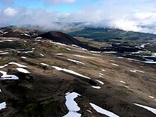
[25] The Arctic Lake Plateau is a nearly flat upland at the southern end of the MEVC between the Spectrum Range to the east and Mess Creek valley to the west.
[30] At least three Big Raven vents occur on the eastern flank of Mount Edziza and comprise another volcanic zone called the east slope centres.
These tuff rings composed of quenched breccia later transitioned into normal subaerial cinder cones as the progressing eruptions displaced ice and meltwater.
[28] The more than 12 km (7.5 mi) long lava flow from Williams Cone formed a temporary dam across the Klastline River at its distal end.
The presence of lacustrine silt in small terraces upstream from the lava flow suggests that both streams were dammed long enough to form temporary lakes.
The largest subaerial cone, Cocoa Crater, produced a 2 km (1.2 mi) wide lava flow that travelled into upper Sezill Creek canyon.
[49] The southwestern flank of Ice Peak and the surrounding Big Raven Plateau are blanketed with loose, air-fall tephra of the Sheep Track Member.
[52] Erosion has largely removed the Sheep Track pumice from drainage channels of small intermittent streams on the upper Big Raven Plateau, but deposits as much as 2 m (6.6 ft) thick occur in interfluvial areas.
Cinder Cliff consists of thin, slaggy basalt flows that ponded against an ice dam in the upper part of Tenchen Valley.
[5] The breach in the eastern crater rim served as a passageway for at least two highly fluid lava flows that travelled north along a drainage system.
[63] The remains consist of steeply dipping beds of coarse agglutinated pyroclastic rocks and basaltic lava flows that overlie thick felsenmeer and talus deposits.
[5] At the southern end of the Mess Lake Lava Field on the steep, south-facing side of Nagha Creek is the third separate vent called The Ash Pit.
[55] It was also the source of a lava flow that travelled down Nagha Creek valley towards the eastern side of Mess Lake, portions of which are buried under stream gravel, outwash and braided channel deposits.