Mess Creek Escarpment
[7][8][9] The escarpment was named for its association with Mess Creek, a tributary of the Stikine River which flows into Sumner Strait of southeast Alaska.
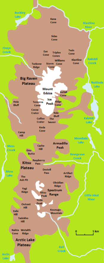
[2][3] The northern segment extends southeast along the southwestern side of the Big Raven Plateau for about 8 km (5.0 mi) and reaches an elevation of 1,700 m (5,500 ft).
[2] The southern segment reaches an elevation of more than 1,700 m (5,500 ft) and extends generally south along the northwestern, western and southwestern edges of the Kitsu Plateau for about 10 km (6.2 mi).
[5][15] The Mess Creek Escarpment lies at the western end of Mount Edziza Provincial Park, a protected area founded in 1972 to showcase the volcanic landscape.
[5][18] The Raspberry Formation consists of flat-lying basaltic lava flows interbedded with scoria and is exposed along the base of the Mess Creek Escarpment where it has an elevation of less than 1,310 m (4,300 ft).
[5] More than 180 m (590 ft) of Raspberry lava flows are exposed in the Mess Creek Escarpment, most of which were erupted from a shield volcano that formed on a Late Miocene erosion surface.
[20][21] These lava flows travelled westward into the ancestral valley of Mess Creek and originated from vents north of Raspberry Pass which were subsequently buried under younger volcanic deposits.
[23] In contrast, the air-fall pumice and ash flows probably originated from the more than 4 km (2.5 mi) in diameter Armadillo Peak caldera east of the Mess Creek Escarpment.
[21][25] The Tenchen Member was erupted from at least three major volcanoes and several smaller satellitic centres which have been either buried under younger volcanic deposits or destroyed by erosion.
[5][29] This basalt mainly erupted as subaerial lava flows which are exposed along the Mess Creek Escarpment for about 8 km (5.0 mi) and are almost completely buried under colluvium deposits on the Big Raven Plateau.
Alkali basalt flows from the two oldest cones travelled westward on the Kitsu Plateau to the edge of the escarpment where they cooled into crude columnar joints.
[5][31] The source of this tephra was The Ash Pit which formed at the southern end of the Mess Creek Escarpment and produced a towering lava fountain.
[5] From near the Eastman Creek Rest Area south of Kinaskan Lake on the Stewart–Cassiar Highway, the historic Yukon Telegraph Trail extends about 15 km (9.3 mi) west to the Little Iskut River.
From there, it enters Mount Edziza Provincial Park and continues another 15 km (9.3 mi) west along Bourgeaux Creek through Raspberry Pass.