Black Triangle (region)
Politically the "triangle" consists of:[4] The Polish portion includes the southernmost "salient" of the Gmina Bogatynia, where the vast Turów Coal Mine has extracted lignite resources since 1904.
In late 1942, under wartime German control, the Czech town of Most began output of Ersatz fuel synthesized from brown coal at the "Sudetenländische Treibstoffwerke AG (STW) Maltheuren plant", operating with forced labor.
As one example of the impact, in 1964 the Mostecká uhelná Company began the demolition of the entire medieval Old Town of Most to make room for the expanding lignite mines.
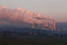
The net result of industrial activity in the Triangle were huge quantities of particulate emissions, heavy metals, sulfur dioxides and nitrogen oxides which largely destroyed adjacent forests of the Jizera Mountains with acid rain,[9][5] and measurable impact on health and life expectancy.
After the Revolutions of 1989 in Eastern Europe, in June 1991 the three nations signed a joint declaration of cooperation to address the Black Triangle's environmental issues.
The bowl-shaped open-pit mine is several kilometers in diameter, about 200 meters deep, and has completely transformed the original geographic character of the Turoszowska Basin.
[10] Czech photographer Josef Koudelka also produced a book about the region, Černý trojúhelník - Podkrušnohoří (The Black Triangle: The Foothills of the Ore Mountain) in 1994.