Boise National Forest
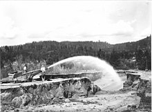
Common land cover includes sagebrush steppe and spruce-fir forests; there are 9,600 miles (15,400 km) of streams and rivers and 15,400 acres (62 km2) of lakes and reservoirs.
Boise National Forest contains 75 percent of the known populations of Sacajawea's bitterroot, a flowering plant endemic to Idaho.
Recreation facilities include over 70 campgrounds, whitewater and flatwater boating, cabin rentals, and 1,300 miles (2,100 km) of trails for hiking, biking, horseback riding, and motorized off-road vehicle use.
The Forest Service has an objective to maintain timber, range, water, recreation, and wildlife for multiple use and sustained yield of its resources.
Archaeological evidence indicates that human habitation in Idaho began towards the end of the last ice age: bone fragments about 10,000 years old have been found in Wilson Butte Cave, an inflationary cave on the Snake River Plain believed to have been occupied by indigenous people until as recently as the 17th century.
[6] A change of climate around 7000 years ago dried up much of the Great Basin, forcing the Shoshone people northward into the mountainous areas of central Idaho.
[7] Most of what is now Boise National Forest was sparsely inhabited by Native Americans, and several archaeological sites, including campsites, rock shelters, burial grounds, and pictographs have been found along rivers in the area.
[9] By 1840, the fur trade was coming to an end, but the westward migration on the Oregon Trail, which passed south of the forest, was beginning.
[19] The Lucky Peak Nursery was established in 1959 to produce trees for planting on burned or logged lands on the national forests of the Intermountain region.
During winter, warm, moist air from the Pacific Ocean often brings rain at lower elevations in addition to snowfall throughout the forest.
Grand fir and western larch (a coniferous deciduous tree) grow in the northern part of the forest where there are moister conditions.
[55] Sacajawea's bitterroot is a plant species endemic to central Idaho, including parts of Boise National Forest, being found nowhere else in the world.
Invasive plants that are of particular concern in Boise National Forest include spotted knapweed, yellow star-thistle, rush skeletonweed, and leafy spurge, among others.
Due to the occurrence of frequent non-lethal fires, ponderosa pine dominates these forests alongside Douglas fir.
Lodgepole pine and quaking aspen may be found alongside Douglas fir in cooler areas, both moist and dry, but particularly where frost pockets form.
[64] At the highest elevations, forests consist of subalpine fir alongside whitebark pine and Engelmann spruce.
Species that commonly occur with sagebrush include Sandberg bluegrass, wild onion, milk vetches, bluebunch wheatgrass, bitterbrush, gray horsebrush, green rabbitbrush, and others.
Riparian areas in largely treeless habitats such as sagebrush steppe primarily consist of willows along with thinleaf alder, chokecherry, mountain maple, shrubby cinquefoil, fireweed, saxifrage, and grasses.
[67] The most common large animals are mule deer and elk, but other mammals present include moose, black bears, cougar, coyote, yellow-bellied marmot, beaver, porcupine, Canadian lynx, mountain goat, pika, river otter, muskrat, pronghorn, mink, bobcat, marten, and timber wolves.
[55][68] Timber wolves are top predators that were reintroduced amidst controversy to central Idaho in the mid-1990s to restore ecosystem stability.
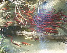
However, due to introductions by humans, Anderson Ranch, Arrowrock, Lucky Peak, and Deadwood reservoirs now support populations of Kokanee salmon.
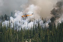
The Trinity Ridge Fire alone burned 146,800 acres (594 km2) over two months, although it was not confined to Boise National Forest lands.
Following severe fires, area closures may be put in place to protect the public from risks such as falling trees and landslides.
[90] There are over 70 campgrounds in Boise National Forest and groups of more developed recreation facilities at the Trinity Mountains, Warm Lake, and Deadwood and Sage Hen reservoirs.
[95] In 2013 revenues from recreation and special use fees amounted to $454,635, while expenses totaled US$352,550; the difference is allocated to the following season's startup costs.
The Bogus Basin ski area is located within the forest north of Boise and has 7 chairlifts and 53 runs on 2,600 acres (11 km2) of skiable terrain.
[97] There are 137 miles (220 km) of groomed snowmobile trails in the Garden Valley system in the Emmett Ranger District[23] and several Mongolian-style yurts available for rental in winter.
[95] Boise National Forest is home to three of Idaho's scenic byways, all of which are paved highways accessible to roadworthy vehicles.
Over half of the 35-mile (56 km) Wildlife Canyon Scenic Byway, which travels between highway 55 and Lowman, passes through the forest, parallels the South Fork of the Payette River, and is signed as the Banks-Lowman Road.
The Ponderosa Pine Scenic Byway is a 130-mile (210 km) road between Stanley and Boise following Idaho State Highway 21.