Bolsover Street
[1][2][3] The predominant land use on Bolsover Street is office business use, mixed with hotels (and YHA Hostel), medical and professional activity.
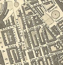
[4] Prior to this, Rocque's map of c 1746 shows the site to be mainly open fields[5] with Bilson's farm located to the north and further buildings to the east.
Small scale hand-dug quarries (pits) for road construction and ponds were also noted to be in the area at that time.
There was also much rebuilding along the eastern side, with several of the terraced houses from the first development demolished in small groups and built over with larger buildings.
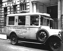
Another factor in Bolsover Street's changing face in the last century has been the continued growth and development of the Royal National Orthopaedic Hospital.
[15] Its buildings are typically presented in red, red/brown or stock brickwork with stone dressings to the windows, entrances and cornice lines.
[16] The predominant land use on Bolsover Street is office business use, hotels[17] mixed with medical and professional activity.