Nansen Ice Sheet
It is nourished by the Priestley and Reeves Glaciers and abuts the north side of the Drygalski Ice Tongue, along the coast of Victoria Land, Antarctica.
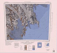
[1] The Nansen Ice Sheet covers the southwest of Wood Bay, on the west coast of the Ross Sea.
An ice-covered pass, 10 nautical miles (19 km; 12 mi) long, lying between the main mass of Deep Freeze Range and the Northern Foothills.
A gently curving glacier, 10 nautical miles (19 km; 12 mi) long, draining southward from Mount Dickason in the Deep Freeze Range to enter Browning Pass, at the north side of Nansen Ice Sheet.
An isolated rock lying 4 nautical miles (7.4 km; 4.6 mi) ENE of Rhodes Head, at the southeast side of Eisenhower Range.
A prominent headland forming the extremity of McCarthy Ridge on the southeast side of Eisenhower Range, overlooking the Nansen Ice Sheet.
Named by US-ACAN for Captain James C. Rhodes, USMCR, an LC-130 aircraft commander with United States Navy Squadron VX-6 for several seasons to 1967.
A broad, mainly ice-covered ridge with steep sides forming the east wall of Carnein Glacier, in the foothills of southeast Eisenhower Range.
A bare rock nunatak lying at the south side of the terminus of Reeves Glacier, 4 nautical miles (7.4 km; 4.6 mi) north of the summit of Mount Gerlache.