Boston Post Road
The Upper Post Road was originally called the Pequot Path and had been in use by Native Americans long before Europeans arrived.
[3] Later, the newly blazed trail was widened and smoothed to the point where horse-drawn wagons or stagecoaches could use the road.
The country's first successful long-distance stagecoach service was launched by Levi Pease along the upper road in October 1783.
Large sections of the various routes are still called the King's Highway and Boston Post Road.
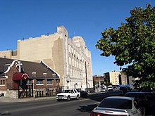
The Metropolitan Railroad Company was chartered in 1853 to run streetcars down the stretch of the road on Washington Street in Roxbury, which is now served by the MBTA Silver Line.
[4] Much of the route in Manhattan, where it was known as the Eastern Post Road, was abandoned between 1839 and 1844, when the current street grid was laid out as part of the Commissioners' Plan that had been originally advanced in 1811.
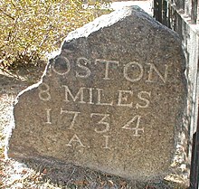
A series of historic milestones erected in the 18th century survive along its route from Springfield to Boston.
The Lower Post Road roughly corresponds to the original alignment of U.S. Route 1 in eastern Connecticut, Rhode Island, and Massachusetts.
Additionally, US 1 leaves the turnpike at the Route 120 intersection to bypass North Attleborough center on East Washington Street.
The Lower Post Road passed through North Attleborough Center on Washington Street, later used as part of the turnpike.
From Hartford, it ran into the Eastern Upper Highlands, an area with large native Indian populations.
It split from the Upper Post Road in Hartford, and initially ran roughly along current U.S. Route 44 through Bolton Notch and towards Mansfield Four Corners.
The post road can be traced along present-day Middle Turnpike East through central Manchester.
Between Bolton and Mansfield, the road passed through the borough of North Coventry, entirely along present-day U.S. Route 44, known locally as the Boston Turnpike.
Along the Willimantic River (and border of Mansfield) stands the Brigham Tavern, which holds the distinction of having housed George Washington around the period of the Revolutionary War.
Before reaching Eastford, however, it takes a right onto Route 244 ("Brayman Hollow Road") which headed directly to Pomfret.
The road once passed through the village of West Thompson, which was flooded purposely to control the Quinebaug River.
The original post road can be seen from the Dam when water levels in West Thompson Lake are low enough.
Crosses the Massachusetts state line into the town of Douglas as Southwest Main Street.
This section passes through Douglas State Forest and is one of the most remote parts of the route that is still used as a public road.
Where Route 16 turns south, the Post Road continues east as Northeast Main Street, which leads to the Uxbridge town line.
French General Lafayette traveled this road to join forces with Washington, and stopped in Douglas during the Revolutionary War.
George Washington stopped here a number of times when traveling this road, including when he took command of the Continental Army at Boston in 1775, and on his post-Inaugural tour of New England in 1789.
The post road followed (present day) Village Street through Millis (part of Medway until 1885).
In the period from 1806 to 1810, the Hartford and Dedham Turnpike was built (now Route 109), nearly going broke in attempting to build a causeway over the Charles River at the Medfield town line and through the Great Black Swamp.
The upper post road (US 20) also runs through Weston, and links directly to The Gifford School Notes Bibliography