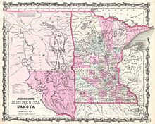
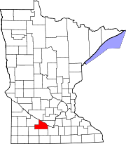
Brown County, Minnesota
It was named for Joseph Renshaw Brown, a member of the Governor's Council of the Territory in 1855.
Redwood was further divided into Lac qui Parle, Lincoln, Lyon and Yellow Medicine Counties in the 1870s.
In 1862, the county's 150-mile northern border was the boundary line of the Upper and Lower Sioux reservations when the 1862 Dakota War broke out.
New Ulm, the county seat, came under heavy attack twice by a superior Mdewakanton Dacotah force that was repulsed.
In 1863, when the treaties with the eastern Dacotah were annulled and the two reservations were dissolved, the county border was moved north 10 miles to the Minnesota River.
The Cottonwood River flows east-northeast through the county's central and upper area, discharging into the Minnesota at the northern border.
The terrain consists of rolling hills, mostly devoted to agriculture,[5] and generally slopes to the east, tending to drop into the river valleys.
[8][9] Most of the county is an area of rich farm land; most of its wetlands were drained for use in agriculture, leaving a number of lakes.
[11] The county has at least 32 lakes,[12] some of which are deemed to be "protected waters" of the State of Minnesota;[13] these are designated with "(p)" below.