Calakmul
Calakmul (/ˌkɑːlɑːkˈmuːl/; also Kalakmul and other less frequent variants) is a Maya archaeological site in the Mexican state of Campeche, deep in the jungles of the greater Petén Basin region.
Calakmul administered a large domain marked by the extensive distribution of their emblem glyph of the snake head sign, to be read "Kaan".
Rediscovered from the air by biologist Cyrus L. Lundell of the Mexican Exploitation Chicle Company on December 29, 1931, the find was reported to Sylvanus G. Morley of the Carnegie Institute at Chichen Itza in March 1932.
[12] At its height in the Late Classic period the city is estimated to have had a population of 50,000 inhabitants and to have covered an area of over 70 square kilometres (27 sq mi).
[10] The Calakmul kingdom included 20 secondary centres, among which were large cities such as La Muñeca, Naachtun, Sasilha, Oxpemul and Uxul.
[16] Calakmul administered a large domain marked by the extensive distribution of their emblem glyph of the snake head sign,[17] to be read "Kaan".
After Calakmul's power dwindled in the 8th century, after the rule of Yuknoom Took K'awiil, it appears that the bat emblem glyph made its resurgence.
This dynasty has been reconstructed in part from Late Classic ceramics from the region of great Preclassic cities of El Mirador and Nakbe.
[28] The earliest legible texts referring to the kings of the Kaan dynasty come from excavations of the large city of Dzibanche in Quintana Roo, far north of Calakmul.
[28] The nearby Quintana Roo site of El Resbalón has a jumbled hieroglyphic text, including a date in 529, that indicates that the city was within the control of the Kaan dynasty.
[36] The immediate aftermath of this second victory over Palenque involved the deaths of the two most important nobles at the city, Ajen Yohl Mat himself and Janab Pakal, a high-ranking member of the royal family and possibly co-ruler.
[39] The wars against Palenque may have been undertaken by Uneh Chan in order to seize control of wealthy trade routes that passed through the western Maya region.
[44] In 629 Tikal had founded Dos Pilas in the Petexbatún region, some 110 kilometres (68 mi) to its southwest, as a military outpost in order to control trade along the course of the Pasión River.
[45] B'alaj Chan K'awiil was installed on the throne of the new outpost at the age of four, in 635, and for many years served as a loyal vassal fighting for his brother, the king of Tikal.
[47] In 679 Dos Pilas, probably aided by Calakmul, gained an important victory over Tikal, with a hieroglyphic description of the battle describing pools of blood and piles of heads.
[51] The power of Calakmul extended as far as the north shore of Lake Petén Itzá, where Motul de San José is recorded as its vassal in the 7th century, although it was traditionally aligned with Tikal.
[55] The next ruler of Calakmul, Split Earth, is mentioned on a pair of carved bones in the tomb of Tikal king Jasaw Chan K'awiil I.
[56] A new defeat at the hands of Tikal is evidenced by a sculpted altar at that city, probably dating to sometime between 733 and 736, depicting a bound lord from Calakmul and possibly names Yuknoom Took' K'awiil.
[57] After this the historical record of Calakmul becomes very vague, due both to the poor state of the heavily eroded monuments at the city itself and also its reduced political presence on the wider Maya stage.
In 736, only two years later, K'ak' Tiliw Chan Yopaat received a visit from Wamaw K'awiil of Calakmul, while Copán was one of Tikal's oldest allies.
The timing of this visit by the king of Calakmul is highly significant, falling between the accession of K'ak' Tiliw Chan Yopaat to the throne of Quiriguá as a vassal of Copán and the outright rebellion that was to follow.
This strongly suggests that Calakmul sponsored Quiriguá's rebellion in order to weaken Tikal and to gain access to the rich trade route of the Motagua Valley.
The fact that Copán, a much more powerful city than Quiriguá, failed to retaliate against its former vassal implies that it feared the military intervention of Calakmul.
[58] Calakmul's presence in the wider Maya area continued to wane, with two of the city's major allies suffering defeats at the hands of Tikal.
[8] Investigations stopped in 1938 and archaeologists did not return to the site until 1982 when William J. Folan directed a project on behalf of the Universidad Autónoma de Campeche, working at Calakmul until 1994.
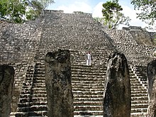
[71] The innermost zone covers an area of approximately 1.75 square kilometres (0.68 sq mi) It contains most of the monumental architecture and has 975 mapped structures, about 300 of which are built from vaulted stone masonry.
[79] Sacbe 5 runs westwards from the main watering hole, across El Laberinto seasonal swamp and carries on for a total distance of 16 kilometres (9.9 mi) or more towards Sasilhá.
[85] In the Early Classic a massive extension was added to the front of the pyramid, covering an earlier stucco-covered building on the north side.
[70] In the Late Classic a nine-room palace was built on top of the pyramid, supporting a roof comb that had painted stucco bas-relief decoration.
The text is damaged but carries an early spelling of the k'uhul chatan winik non-royal noble title used in Calakmul and the Mirador Basin.