Garonne Canal
Together, they and the Garonne form the Canal des Deux Mers which connects the Mediterranean Sea to the Atlantic Ocean.
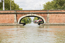
It is connected to the Canal du Midi at its source in Toulouse, and emerges at Castets-en-Dorthe on the Garonne, 54 km southwest of Bordeaux, a point where the river is navigable.
The primary difficulty was in supplying sufficient water at the watershed between the Mediterranean and the Atlantic to ensure continuous navigation.
Drawing on his knowledge of the Montagne Noire and its watercourses, Riquet's scheme diverted water from multiple streams and rivers to the Mediterranean-Atlantic watershed boundary near Seuil de Naurouze.
He was inspired by Adam de Craponne's theories, which had been used earlier by Hugues Cosnier to construct the Briare Canal.
Riquet may have intended to extend the canal westwards toward the Atlantic, but that was not done; the state could not afford the work since it was expanding the Château de Versailles, and Louis XIV had poor finances.
The Becquey Plan of 1821 to 1822 proposed the improvement of waterways in France to expand haulage in support of the Industrial Revolution.
Construction began at several points simultaneously, with thousands of workmen building the 193 kilometres of canal and other structures like the Agen aqueduct.
At first, the railway did not compete with water transport, but the state later conceded the canal's exploitation rights to the Compagnie des chemins de fer du Midi, the direct competitor of the boatmen.
The economic impact of this activity is important and raises 10-60% the parts of the economy relating to the canal in the towns and villages through which it passes.