River engineering
"[1] River engineering has often resulted in unintended systematic responses, such as reduced habitat for fish and wildlife, and alterations of water temperature and sediment transport patterns.
[2] Beginning in the late 20th century, the river engineering discipline has been more focused on repairing hydromodified degradations and accounting for potential systematic response to planned alterations by considering fluvial geomorphology.
Fluvial geomorphology is the cumulation of a number of sciences including open channel hydraulics, sediment transport, hydrology, physical geology, and riparian ecology.
River basins vary in extent according to the configuration of the country, ranging from the insignificant drainage areas of streams rising on high ground very near the coast and flowing straight down into the sea, up to immense tracts of great continents, where rivers rising on the slopes of mountain ranges far inland have to traverse vast stretches of valleys and plains before reaching the ocean.
In tropical countries subject to periodical rains, the rivers are in flood during the rainy season and have hardly any flow during the rest of the year, while in temperate regions, where the rainfall is more evenly distributed throughout the year, evaporation causes the available rainfall to be much less in hot summer weather than in the winter months, so that the rivers fall to their low stage in the summer and are very liable to be in flood in the winter.
In fact, with a temperate climate, the year may be divided into a warm and a cold season, extending from May to October and from November to April in the Northern hemisphere respectively; the rivers are low and moderate floods are of rare occurrence during the warm period, and the rivers are high and subject to occasional heavy floods after a considerable rainfall during the cold period in most years.
[4] Another serious obstacle encountered in river engineering consists in the large quantity of detritus they bring down in flood-time, derived mainly from the disintegration of the surface layers of the hills and slopes in the upper parts of the valleys by glaciers, frost and rain.
Nevertheless, where the available fall is exceptionally small, as in land originally reclaimed from the sea, such as the English Fenlands, and where, in consequence, the drainage is in a great measure artificial, straight channels have been formed for the rivers.
The removal of obstructions, natural or artificial (e.g., trunks of trees, boulders and accumulations of gravel) from a river bed furnishes a simple and efficient means of increasing the discharging capacity of its channel.
[4] Human intervention sometimes inadvertently modifies the course or characteristics of a river, for example by introducing obstructions such as mining refuse, sluice gates for mills, fish-traps, unduly wide piers for bridges and solid weirs.
By placing these embankments somewhat back from the margin of the river-bed, a wide flood-channel is provided for the discharge of the river as soon as it overflows its banks, while leaving the natural channel unaltered for the ordinary flow.
In this manner, the increased cost of embankments raised above the highest flood-level of rare occurrence is avoided, as is the danger of breaches in the banks from an unusually high flood-rise and rapid flow, with their disastrous effects.
Longitudinal sections of the Po River, taken in 1874 and 1901, show that its bed was materially raised during this period from the confluence of the Ticino to below Caranella, despite the clearance of sediment effected by the rush through breaches.
This loss of fish diversity and abundance is thought to occur because of reduction in habitat, elimination of riffles and pools, greater fluctuation of stream levels and water temperature, and shifting substrates.
"[8][needs update] The major agency involved in the enforcement of this policy is the same Army Corps of Engineers, which for many years was the primary promoter of wide-scale channelization.
[9] The U.S. Clean Water Act regulates certain aspects of channelization by requiring non-Federal entities (i.e. state and local governments, private parties) to obtain permits for dredging and filling operations.
[10] Rivers whose discharge is liable to become quite small at their low stage, or which have a somewhat large fall, as is usual in the upper part of rivers, cannot be given an adequate depth for navigation purely by works which regulate the flow; their ordinary summer level has to be raised by impounding the flow with weirs at intervals across the channel, while a lock has to be provided alongside the weir, or in a side channel, to provide for the passage of vessels.
Navigation, however, is liable to be stopped during the descent of high floods, which in many cases rise above the locks; and it is necessarily arrested in cold climates on all rivers by long, severe frosts, and especially by ice.
[4] As rivers flow onward towards the sea, they experience a considerable diminution in their fall, and a progressive increase in the basin which they drain, owing to the successive influx of their various tributaries.
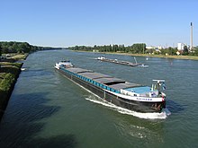
Eventually, large rivers, under favorable conditions, often furnish important natural highways for inland navigation in the lower portion of their course, as, for instance, the Rhine, the Danube and the Mississippi.
A soft shoal in the bed of a river is due to deposit from a diminution in velocity of flow, produced by a reduction in fall and by a widening of the channel, or to a loss in concentration of the scour of the main current in passing over from one concave bank to the next on the opposite side.
A typical solution is to restrict the width of the low-water channel, concentrate all of the flow in it, and also to fix its position so that it is scoured out every year by the floods which follow the deepest part of the bed along the line of the strongest current.