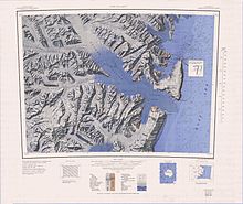
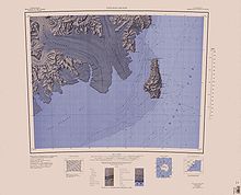
Daniell Peninsula
It was named by the New Zealand Geological Survey Antarctic Expedition (NZGSAE), 1957–58, after Cape Daniell, and by analogy with the Adare and Hallett peninsulas.
A small peak, 2,025 metres (6,644 ft) high, that rises above the general level of the central part of Daniell Peninsula and marks its greatest elevation.
A coastal peak, 1,630 metres (5,350 ft) high, rising immediately north of Cape Jones at the south end of Daniell Peninsula.
Small ice-covered peak, 1,220 metres (4,000 ft) high, situated 3.5 nautical miles (6.5 km; 4.0 mi) northwest of the summit of Mount Lubbock in the south end of Daniell Peninsula, Victoria Land.
A narrow, but elevated isthmus or neck of land between Langevad Glacier and Mandible Cirque in the south part of Daniell Peninsula.
The feature serves to join Tousled Peak and the Mount Lubbock vicinity to the main mass of Daniell Peninsula.
A spectacular cirque indenting the coast of Daniell Peninsula 5 nautical miles (9.3 km; 5.8 mi) west-southwest of Cape Phillips.
A cape approximately midway along the east side of Daniell Peninsula, 8 nautical miles (15 km; 9.2 mi) southeast of Mount Brewster.
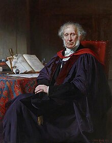
Discovered, January 15, 1841, by Sir James Clark Ross who named it for Professor John Frederic Daniell, chemist of King's College, Cambridge University, and Foreign Secretary of the Royal Society.