Ceredigion
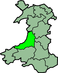
It borders Gwynedd across the Dyfi estuary to the north, Powys to the east, Carmarthenshire and Pembrokeshire to the south, and the Irish Sea to the west.
The mountains are the source of the county's main rivers: the Rheidol, Ystwyth, Aeron and Teifi; the last of these is Ceredigion's boundary with Carmarthenshire and Pembrokeshire for most of its length.
In the 18th and early 19th centuries, the county was more industrialised than it is today; lead, silver and zinc were mined in the area, and Cardigan was the largest port in South Wales.
A total of 170 hill forts and enclosures have been identified across the county and there are many standing stones dating back to the Bronze Age.
The Sarn Helen road ran through the territory, with forts at Bremia and Loventium protecting gold mines near present-day Llanddewi Brefi.
The 9th-century History of the Britons attributed to Nennius records that Cunedda's son Ceredig settled the area around the Teifi in the 5th century.
[5] The territory supposedly remained a minor kingdom under his dynasty until its extinction upon the drowning of Gwgon ap Meurig c. 871, after which it was administered by Rhodri Mawr of Gwynedd before passing to his son Cadell, whose son Hywel Dda inherited its neighbouring kingdom Dyfed and established the realm of Deheubarth.
Records are highly obscure; some historians believe that Hyfaidd ap Bledrig, the Dyfed ruler, may have annexed Ceredigion before his heirs lost it to Hywel through war.
Some came by sea and made use of the churches at Mwnt and Penbryn, while others came by land seeking hospitality at such places as Strata Florida Abbey.
[9] In the 18th century there was an evangelical revival of Christianity, and nonconformism became established in the county as charismatic preachers like Daniel Rowland of Llangeitho attracted large congregations.
[14][15][16] Ceredigion is a coastal county, bordered by Cardigan Bay to the west, Gwynedd to the north, Powys to the east, Carmarthenshire to the south and Pembrokeshire to the south-west.
[17] The main settlements are Aberaeron, Aberporth, Aberystwyth, Borth, Cardigan, Lampeter, Llanarth, Llanddewi Brefi, Llandysul, Llanilar, Llanrhystud, Llanon, New Quay, and Tregaron.
[18] The Cambrian Mountains cover much of the east of the county; this large area forms part of the desert of Wales.
The highest point is Plynlimon (Pumlumon) at 2,467 feet (752 m), other Marilyns include Pen y Garn and Llan Ddu Fawr.
On the slopes of Pumlumon five rivers have their sources: the Severn, the Wye, the Dulas, the Llyfnant and the Rheidol, the last of which meets the Afon Mynach in a 300 feet (91 m) plunge at the Devil's Bridge chasm.
The towns of Lampeter, Llandysul, Newcastle Emlyn and Cardigan are all in the Teifi Valley, and each has communities on each side of the river, in different counties.
Before the first railway was built in 1866, the stock used to be herded over the mountains to England, where Rugby, Northampton and London were important destinations.
By the first half of the 20th century, falling livestock prices and greater international competition made farming unprofitable.
Many residents of Cardiganshire moved to other parts of South Wales, where there were better employment opportunities, and many more emigrated to the United States, Canada, Patagonia and Australia.
[17] Furthermore, the owners of the great landed estates, who had for so long dominated the politics of the county, were in many cases heavily in debt.
More retired people were arriving to make their home in the tranquil surroundings, and after the Beacham Commission in the 1960s, the British government realised that the rural way of life in parts of Wales was in crisis, and started to react.
[17] However, in 2011, at 3.1%, Ceredigion still had one of the highest proportions of its population working in agriculture, forestry and fishing, close behind such other places as Orkney and Shetland.
[44] Other visitor attractions include the Cwmystwyth Mines, Llywernog Mine, Devil's Bridge,[39] the Bwlch Nant yr Arian Forest Visitor Centre,[39][45] Elvis Rock, Cors Caron (Tregaron bog), the Vale of Rheidol Railway,[39] and the Aberystwyth Cliff Railway.
[50] The county's main football team, Aberystwyth Town in the Cymru Premier, play their home matches at Park Avenue Stadium.
The Fishguard to Bangor trunk road, the A487, travels in a north-east direction following the coast from Cardigan to New Quay, through Aberaeron and Aberystwyth.
A bus service known as Bwcabus operates in the south of the county, offering customised transport for rural dwellers.
The recordings were archived, digitised, catalogued and made available during the Unlocking Our Sound Heritage project at the National Library of Wales.