Cartography of India
A prominent medieval cartographer was Persian geographer Abu Rayhan Biruni (973–1048) who visited India and studied the country's geography extensively.
Joseph E. Schwartzberg (2008) proposes that the Bronze Age [[Indus Valley Civilization]] (c. 2500–1900 BCE) may have known "cartographic activity" based on a number of excavated surveying instruments and measuring rods and that the use of large scale constructional plans, cosmological drawings, and cartographic material was known in India with some regularity since the Vedic period (1st millennium BCE).
In the 8th century CE the Kailas temple at Ellora in Maharashtra was carved down into mountain for 100 feet, with intricate sculptures lining pillared halls, no easy task even with an exact map to follow, impossible without.
In Greek cartography, India appears as a remote land on the eastern fringe of Asia in the 5th century BCE (Hecataeus of Miletus).
Early forms of cartography in India included legendary paintings; maps of locations described in Indian epic poetry, for example the Ramayana.
Also considered in the study were copper-plate text inscriptions on which the boundaries of land, granted to the Brahman priests of India by their patrons, were described in detail.
[2] The Chinese records of the Tang dynasty show that a map of the neighboring Indian region was gifted to Wang Hiuen-tse by its king.
[14] The Iranian geographers Abū Muhammad al-Hasan al-Hamdānī and Habash al-Hasib al-Marwazi set the Prime Meridian of their maps at Ujjain, a centre of Indian astronomy.
[15] In the early 11th century, the Persian geographer Abu Rayhan Biruni visited India and studied the country's geography extensively.
[16] In 1154, the Arab geographer Muhammad al-Idrisi included a section on the cartography and geography of India and its neighboring countries in his world atlas, Tabula Rogeriana.
[17] Italian scholar Francesco Lorenzo Pullè reproduced a number of Indian maps in his magnum opus La Cartografia Antica dell'India.
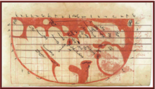
[11] According to Joseph E. Schwartzberg (2008): 'The largest known Indian map, depicting the former Rajput capital at Amber in remarkable house-by-house detail, measures 661 × 645 cm.
One British observer commented on the tradition of native Indian cartography: Besides geographical tracts, the Hindus have also maps of the world according to the system of the puranics and of the astronomers: the latter are very common.
To achieve the highest accuracy a number of corrections were applied to all distances calculated from simple trigonometry: Thomas George Montgomerie organized several cartographic expeditions to map Tibet, as well as China.