Carver County, Minnesota
[5] Carver County is part of the Minneapolis-St. Paul-Bloomington, MN-WI Metropolitan Statistical Area.
[14] In 2018, Carver County was ranked as the #1 "Happiest Place in America" according to a study conducted by the data firm Smart Asset.
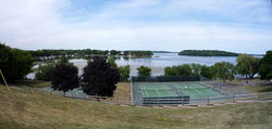
[15] The Minnesota River flows east-northeasterly along the county's southern border.
The South Fork of the Crow River flows northeasterly through the upper western and central portions of the county.
The terrain consists of low rolling hills, dotted with lakes in the eastern portion.
[2] The terrain slopes to the east and south, with its northwest corner at 1,024 ft (312 m) ASL.
[17] A small hill 1.6 miles (2.6 km) northeast of Miller Lake[2] rises to 1,080 ft (330 m) ASL, for the county's highest point.
The ethnic makeup of the county, according to the 2010 census, was the following: There were 33,486 households, out of which 42.1% had children under the age of 18 living with them, 62.9% were married couples living together, 7.6% had a female householder with no husband present, and 25.9% were non-families.
21.0% of all households were made up of individuals, and 6.9% had someone living alone who was 65 years of age or older.
18.10% of all households were made up of individuals, and 6.10% had someone living alone who was 65 years of age or older.
Since 1980, only Bill Clinton and Joe Biden have held the Republican nominee to a single-digit margin of victory.
However, despite the county's Republican lean, it has become much more competitive in recent elections, with Joe Biden in 2020 receiving the highest vote share of any Democratic presidential nominee since Lyndon B. Johnson in his 1964 landslide victory.
Carver County is located in Minnesota's 6th congressional district (CPVI R+12), represented by Republican Tom Emmer.