Cat and Fiddle Road
Formed by parts of the A537, A54 and A53, it is famous for its scenic views across the Greater Manchester conurbation, the Peak District National Park and the Cheshire Plain, and for its many bends.
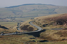
It then climbs in a series of sharp bends onto the flat moorland of Goyt's Moss, where it runs as the A537 in a fairly straight line until it reaches the Cat and Fiddle Inn (which closed in late 2016 and reopened as a distillery and bottle shop in 2020).
It is part of the "Cat and Fiddle – Long Hill – Highwayman" triangle, which is particularly attractive to motorcyclists because of the frequency and severity of the bends.
Given this mixture of usage, the number and sharpness of the bends and the frequent straying livestock on the road, a great deal of caution is needed.
The Cat and Fiddle Road was used as part of the route of the third stage of the 2016 Tour of Britain from Congleton to Tatton Park, forming the longest and highest climb of that year's race.
The report states that the safety issue is caused by "severe bends, steep falls from the carriageway and edged by dry-stone walls for almost the entirety of the road".
The road is regularly patrolled by unmarked police cars and motorcycles and a mobile speed camera van is used most weekends during the summer.
Of the 264 casualties on the road since 2001, approximately 70% of those killed or seriously injured were motorcyclists, the main causes being poor cornering/manoeuvring, exceeding the speed limit and failing to judge another vehicle’s speed/distance.