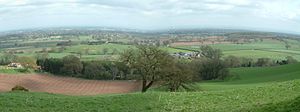
Cheshire Plain
In detail, the plain comprises two areas with distinct characters, the one to the west of the Mid Cheshire Ridge and the other, larger part, to its east.
It assumed its current form as the ice-sheets of the last glacial period melted away between 20,000 and 15,000 years ago leaving behind a thick cover of glacial till and extensive tracts of glacio-fluvial sand and gravel.
The primary agricultural use of the Cheshire Plain is dairy farming, creating the general appearance of enclosed hedgerow fields.
Meteorologists use the term Cheshire Gap when referring to the lowlands of the Cheshire Plain, providing as they do a passage between the Clwydian Hills, in Wales on the one hand and the Peak District and South Pennines on the other.
Weather systems are often guided down this "gap", penetrating much further inland than elsewhere along the coast of the Irish Sea.