Cosdon Hill
[2] The surveyors of the Principal Triangulation of Great Britain took bearings that resulted in the first Ordnance Survey map of Dartmoor in 1809, which showed that Yes Tor was higher.
[4] An 1894 guide for cyclists going from Exeter to Launceston said, "So vast is the bulk of Cosdon that, were is not for the cloud mists that so often drift round his brow, one would hardly at first sight credit his height of 1799 feet."
As Thomas Clifton Paris wrote in 1865, "Far and wide stretch its desolate hills, the ancient haunt of wolves and wild deer, and barbarians as untamed; a solitary wondrous region, everywhere darkened by morasses, but piled with fantastic rocks and glowing with innumerable tints.
There were nine Bronze Age settlements around the western edge of the hill and two associated reaves, or stone walls, that may have marked the boundaries between territories.
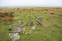
[2] An 1896 report described three parallel lines of stones, starting from a cairn surrounded by a circle, on the North Tawton Common on the east side of Cosdon.
[9] Samuel Rowe (1793–1853), Vicar of Crediton, noted in 1848 that they started at a point near the foot of the hill called Hoga de Cosdowne, and said this must have been near the banks of the Taw close to Sticklepath.
[2] Elias Tozer (1825–73) wrote,[2] Rolling o’er the purple heather, In the glorious Summer weather, Staining lips with whortleberries, Sweet as any figs or cherries.
Gazing over boundless plain, List’ning to the sweet refrain Of the rivulets and rills As they flow by distant hills;