Cederberg
The Cederberg mountains are located near Clanwilliam, approximately 300 km north of Cape Town, South Africa at about 32°30′S 19°0′E / 32.500°S 19.000°E / -32.500; 19.000.
Cederberg is now the generally accepted spelling for the area, which combines the English (Cedarberg) and Afrikaans (Sederberg) variants.
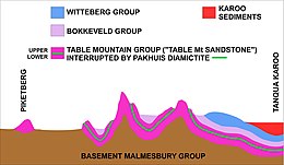
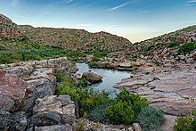
The dominating characteristic of the area is sharply defined sandstone rock formations (Table Mountain Group), often reddish in colour.
This group of rocks contains bands of shale and in recent years a few important fossils have been discovered in these argillaceous layers.
[3] The summers are very hot and dry, while the winters are wetter and cold with typical annual rainfall in the low-lying areas of less than 700 mm.
Due to the clear skies most of the year, it makes an excellent site for skywatching and has its own amateur observatory.
The predominant vegetation is Mediterranean fynbos in the wetter south and west, changing to semi desert scrub in the north and east.
In caves and overhangs throughout the area, San rock art can be found, evidence of the earliest human inhabitants.
European settlement brought forestry and some agriculture, and led to massive destruction of the local cedar trees, with thousands felled for telephone poles, furniture and housing.
In the north, the old Moravian mission station of Wupperthal still remains, the heart of a small subsistence farming community, and home to a local industry producing veldskoene, traditional soft leather shoes.
The quaint village of Wupperthal forms part of a mission station route that provides visitors with an interesting view of rural life.