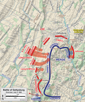
Cemetery Ridge
The northern end rises to become Cemetery Hill, the southern descends to low, wooded, and sometimes marshy ground just north of Little Round Top.
At the northern end of Cemetery Ridge is a copse of trees and a low stone wall that makes two 90-degree turns; the latter has been nicknamed The Angle and is also referred to as the High Water Mark of the Confederacy.
This area, and the nearby Codori Farm on Emmitsburg Road, were prominent features in the progress of Pickett's Charge during the third day of battle, as well as Major General Richard H. Anderson's division assault on the second.
[2] During the morning of the battle's 2nd day (July 2), Army of the Potomac commander Maj. Gen. George G. Meade shifted units to receive an expected Confederate attack on his positions.
[5] Heavy rifle and artillery fire prevented all but about 250 Confederates led by Lewis Armistead from penetrating the Union line to the high water mark of the Confederacy.