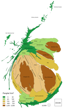
Central Belt
In the early 21st century, predictions were made that due to economic migration indicators, the urban areas of Glasgow and Edinburgh, whose centres are approximately 41 miles (66 km) apart, could merge to create a megalopolis over the coming decades.
[5] encompassing towns such as Paisley, Cambuslang, Hamilton, Stirling, Falkirk, Cumbernauld, Livingston and Bathgate.
This also takes in fairly densely populated regions such as Ayrshire and East Lothian, and encompasses all the major cities of Scotland, except for Aberdeen and Inverness which are located in the north of the country, as well as the bulk of Scotland's industrial works.
Including rural parts of the council areas involved,[c] the total population was around 4.28 million in 2018.
[6] There are several terms in common usage in a Scottish context with a similar meaning to "Central Belt".