Charles Jacot-Guillarmod
Born in La Chaux-de-Fonds, he lived in Vevey with his parents before he went to Zurich studying to become a surveying engineer at Swiss Federal Institute of Technology, where he graduated in 1890.
Rapidly recognised for a new way of rock presentation, he contributed to the establishment of the Topographical Atlas of Switzerland (the so-called Siegfried map).
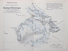
In 1914, he established two topographical maps of K2 and Kangchenjunga based on photographs taken mainly by his cousin, the physician and mountaineer Jules Jacot Guillarmod.
[3] They were printed by Kümmerly & Frey, Bern and published by the Bulletin of the geographical society of Neuchatel in 1925.
[6] At the request of the Royal Geographical Society, London, he produced the first topographic map of Mount Everest on the basis of photographs from two English expeditions carried out in the region.