Charmant Som
They are accessible via a road built between the two world wars from the Col de Porte to 200 metres (660 ft) below the main summit.
It was attested as Charmencson in 1357, Charmenson in 1540, Chalmenson in the Titres de la Grande Chartreuse in the 17th century, Charmanson in 1700 (Réformation des forêts, II) and 1725 (new Titres de la Grande Chartreuse),[1][2] Charmant Som on the Cassini map in the 18th century.
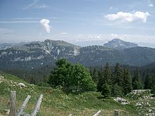
The southern branch, known as the Canaple ridge, has a gentler slope and is home to alpine pastures to which the D57d departmental road leads from the Col de Porte.
[15] Bird species at Charmant Som include the Golden Eagle, Wallcreeper, Alpine chough and Black Grouse.
[14] The rocky outcrops and forests of sycamore maple and Norway spruce[13][16] are remarkable for their floristic diversity, and are home to some rare protected species.
[13][14] Other species found in these environments include the Aconitum anthora, the Aconitum variegatum, the Allium victorialis, the Arabis serpyllifolia, the Bupleurum longifolium, the Campanula latifolia, the Centranthus angustifolius, the Chrysosplenium oppositifolium, the Circaea alpina, the Clematis alpina, the Cystopteris montana, the Daphne alpina, the Galium obliquum, the Galium pseudohelveticum, the Gentiana cruciata, the Gymnadenia odoratissima, the Helictotrichon setaceum, the Hieracium lawsonii, the Hypericum nummularium, the Impatiens noli-tangere, the Laserpitium gallicum, the Limodorum abortivum, the Neottia cordata, the Lunaria rediviva, the Minuartia capillacea, the Orobanche laserpitii-sileris, the Peucedanum carvifolium, the Polystichum aculeatum, the Polystichum setiferum, the Potentilla nitida, the Primula auricula, the Rhodiola rosea, the Saxifraga muscoides, and the Tozzia alpina.
[13] The Viola calcarata, the Narcissus pseudonarcissus, the Dactylorhiza sambucina, the Trollius europaeus, the Gymnadenia nigra, the Lilium martagon, the Gentiana angustifolia, and the Veratrum album usually bloom on the 200 hectares of alpine pastures, which are maintained by pastoralism.
[17][18] In the Middle Ages, Charmant Som was first owned by the Bonnevaux Abbey, founded in what is now the commune of Villeneuve-de-Marc, which made a short transhumance to the mountain from the Terres froides.
[20] After World War I, it was bought by the National Forests Office, who leased it by adjudication to Provençal shepherds, who re-established transhumance, resulting in the temporary loss of local cheese production.
[19] However, between 1932 and 1937, these same shepherds took advantage of the opportunity to build the current road in place of the old mule track leading to the mountain pastures.
[19] The Touring club de France, present in Saint-Pierre-de-Chartreuse since the founding of a tourist office in 1905 and encouraged by the commune's classification as a health resort,[21] helped to make the road viable.
[23] In 1941, in the midst of the scarcity caused by World War II, the National Forests Office decided to lease the mountain pastures to an entrepreneur from Les Adrets, who immediately handed over management to a resident of Theys, with the cattle being driven from these two Dauphiné villages at the foot of the Belledonne to the Chartreuse Mountains.
Initially supported by the Vichy France regime, these camps became part of the Resistance at the end of the war, taking in those who had refused Compulsory Work Service (STO) and joined the Maquis.
[19] The Criska chasm was discovered in 1962 with the help of the eponymous[24] dog of the Speleo-club cartusien, then explored by a member of the Grenoble Speleos of the Fédération Française des clubs alpins et de montagne (FFCAM by its acronym in French).
During the summer of 1967 and spring of 1968, the Fontaine-La Tronche Speleo-group had to deal with a number of obturations, artificially widening the cave by blasting.
Due to a lack of investment and after several vandalism incidents, operations ceased in the mid-2000s; unlike the rest of the Col de Porte resort, the chairlift was not reopened in 2009.
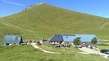
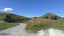
The classic hiking route starts at the Chalets du Charmant Som, at the end of the D57d departmental road accessible from the Col de Porte.
[40] Despite the closure of the chairlift, the old red trail is still suitable for ski mountaineering between its downstream end and its junction with the road under Canaple.
[50] It is possible to start from the lower part of the slabs, below the path, by taking the approach walk from the hamlet of Les Revols.
[51] The Dièdre oublié route, opened in 1996, is located on the western slope and features passages rated 6b for a total height of 80 metres (260 ft).
In 1991, dyes revealed its resurgence at Porte de l'Enclos in the Gorges du Guiers Mort, at an altitude of 780 metres (2,560 ft), at the end of the Bérard ridge.
The take-off area is located in the limestone slabs on the eastern face, and enjoys good aerological conditions in the morning.
[55][56] Charmant Som is located within the Chartreuse Regional Nature Park, which was created in 1995 and, since the revision of its charter in 2008, covers 767 km2 (296 sq mi).