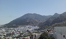
Chefchaouen Province
Forest formations are distributed according to local variations of climate and soil due to altitude, lithology, and human activity.
[clarification needed] It is designated as a Mediterranean biodiversity hotspot (i.e. a zone with an exceptional concentration of endemic and threatened species) and suffers from accelerated forest degradation due to anthropogenic pressures exacerbated by the impact of climate change.
[11] Despite the significant rainfall, agricultural activity is limited due to the rugged and steep topography, the scarcity of arable land, the low mechanization level, and the lack of irrigation infrastructure.
[12] The province is dominated by cereal agriculture, goat herding in the mountains, and arboriculture of fig and almond trees.
[citation needed] This traditional agro-pastoral system – of olive and fig plantations, cereal fields, and limited grazing pastures – has been carried out for centuries.
These various agricultural models have contributed to a richness of food diversity and, in 2010, UNESCO recognized Chefchaouen for its Mediterranean diet.
The commercial sector is one of the main economic supports of Chefchaouen, bolstered by tourism activity and remittances from workers abroad.