Chew Valley Lake
Before the lake was created, archaeological investigations were carried out that showed evidence of occupation since Neolithic times and included Roman artefacts.
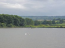
Some restricted use for recreational activities is permitted by the owner, Bristol Water, including dinghy sailing and fishing, primarily for trout.
Facilities include a tea shop, with indoor and outdoor seating areas with a view of the lake, and information centre.
The Grebe Trail[4] is a hard-surfaced, all-weather path suitable for pedestrians, pushchairs and wheelchairs and covers a circuit 0.75 miles (1.2 km) long, starting and finishing at the wooded picnic area.
The trail runs along the east shore, visits an open bird hide and returns to the footbridge, making a 1-mile (1.5-kilometre) circuit.
Visitors are officially invited to use public transport, but overwhelmingly arrive by private car, encouraged by the provision of parking spaces.
It was funded by Bath and North East Somerset Council with the support of Sustrans and the Chew Valley Recreational Trail Association.
The nearest major road is the A368, which runs along the southern edge of the lake and provides access from Bath and Weston super Mare.
Farms and houses had to be removed before the land was flooded, and old roads, hedgerows and tree stumps can reappear when dry summers cause the level of the lake to drop.
Prior to the flooding of the reservoir, archaeological excavations were carried out by Philip Rahtz and Ernest Greenfield employed by the Ministry of Works, from 1953 to 1955.
[8] Further evidence of Neolithic and Bronze Age occupation is provided by the archaeological survey of the Mendip Hills Area of Outstanding Natural Beauty.
[8] Further excavations around the village of Moreton, which has now been totally submerged, found evidence of a thriving community in medieval times and possibly the remains of the Nunnery of Santa Cruz.
[10] During the Middle Ages farming was the most important activity in the area covered by the lake, supported by four flour mills powered by the River Chew.
[11] Plans for the building of the reservoir were under discussion before the Second World War, and an act of parliament submitted by the Bristol Waterworks Company was passed in 1939.
[12] The lake was inaugurated by Queen Elizabeth II, accompanied by Prince Philip, with the unveiling of a commemorative stone and plaque, which can be seen from the dam, on 17 April 1956, although it was not full until 25 February 1958.
During the storm of 10 July 1968, the lake gained an extra 471 million imperial gallons (2,140,000 m3) and rose 19 inches (480 mm) in under 12 hours.
At one point worried Bristol police issued a warning that the dam might not hold, prompting localised evacuation of populated valley areas downstream including Pensford and Keynsham.
[15] The main geological outcrops around the lake are mudstone, largely consisting of red siltstone resulting in the underlying characteristic of the gently rolling valley landscape.
A shallow pool fringed with sedges (Cyperaceae), rushes (Juncaceae) and reedgrasses (Calamagrostis) and surrounded by lightly grazed, rough grassland may also prove attractive to snipe and lapwings.
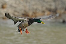
[20] Chew Valley also holds a large population of pike (Esox lucius), and fishing for these is permitted at certain times of the year.
[21] Large populations of dragonflies, including migrant hawker (Aeshna mixta) and significant numbers of ruddy darter (Sympetrum sanguineum), occur at the lake.
On neutral soils around the reservoir, pepper-saxifrage (Silaum silaus), burnet-saxifrage (Pimpinella saxifraga) and devil's-bit scabious (Succisa pratensis) occur, and on calcareous soils fairy flax (Linum catharticum), dwarf thistle (Cirsium acaule) and salad burnet (Sanguisorba minor subspecies minor) are found.
Mature oak (Quercus) and ash (Fraxinus excelsior) trees are characteristic of the area with occasional groups of Scots pine (Pinus sylvestris) and chestnuts (Castanea sativa).
[22] These forests contain Scots pine (Pinus sylvestris), English oak (Quercus robur), rowan (Sorbus aucuparia) and the silver birch (Betula pendula).
Permits to enter the reservoir enclosure and to use the access roads, paths and bird hides are available (for a fee) only to members of ornithological and naturalist societies recognised by Bristol Water.