Chew Valley
It is bounded by higher ground ranging from Dundry Down and the south western boundary of Keynsham town to the north, the Lulsgate Plateau to the west, the Mendip Hills to the south and the Hinton Blewett, Temple Cloud, Clutton and Marksbury plateau areas to the east.
The lake is a prominent landscape feature of the valley, a focus for recreation, and is internationally recognised for its nature conservation interest, because of the bird species, plants and insects.
Many of the villages date back to the time of the Domesday Book and there is evidence of human occupation since the Stone Age.
One explanation is that the name Chew began in Normandy as Cheux, and came to England with the Norman Conquest during the eleventh century.
The western end of the area (around Nempnett Thrubwell) consists of the Harptree Beds which incorporate silicified clay, shale and Lias Limestone.
[7] The mudstones around the lakes give rise to fertile silty clay soils that are a dull dusky red colour because of their high iron content.
The clay content means that where unimproved they easily become waterlogged when wet, and hard with cracks and fissures during dry periods.
[7] The main geological outcrops around the lake are mudstone, largely consisting of red Siltstone resulting in the underlying characteristic of the gently rolling valley landscape.
It takes the form of rock fragments mainly derived from older Carboniferous Limestone cemented together by lime and sand which hardened to give the appearance of concrete.
[7] The northern boundary is formed by the sides of the Dundry Plateau where the most significant geological formation is the Inferior Oolite of the Jurassic period found on the higher ground around Maes Knoll.
Most of the area around Stanton Drew have neutral to acid red loamy soils with slowly permeable subsoils.
[7] The valley has several areas designated as Site of Special Scientific Interest (SSSI) for biological interest, including Blagdon Lake,[11] Burledge Hill,[12] Chew Valley Lake,[13] Compton Martin Ochre Mine,[14] Harptree Combe[15] and two sites at Folly Farm.
Mature oak (Quercus) and ash (Fraxinus excelsior) trees are characteristic of the area with occasional groups of scots pine (Pinus sylvestris) and chestnuts (Castanea sativa).
The valley also has a wide variety of small mammals with larger species including Eurasian badger and deer.
A rare and endangered species, the greater horseshoe bat is protected under the Wildlife and Countryside Act 1981 and is listed in Annex II of the 1992 European Community Habitats Directive.
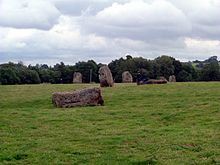
[19][20] Other evidence of occupation from prehistoric times is provided by the henge monument at Stanton Drew,[21] long barrow at Chewton Mendip,[22] and Fairy Toot tumulus at Nempnett Thrubwell.
[23][24] Maes Knoll fort, on Dundry Down in the northern reaches of the valley, is a Scheduled Ancient Monument that dates from the Iron Age; it later served as a terminus for the early medieval Wansdyke earthworks.
[28] In the summer the Azores high pressure affects the south-west of England, however convective cloud sometimes forms inland, reducing the number of hours of sunshine.
In summer, a large proportion of the rainfall is caused by sun heating the ground leading to convection and to showers and thunderstorms.
[28] Many of the large houses in the valley were built or bought by wealthy merchants from Bristol and Bath who employed local people in their households.
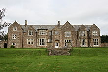
[30] Bess of Hardwick (1527–1606) is known to have lived in Sutton Court, Stowey, for a few years in the sixteenth century when, after the death of her first husband Sir William Cavendish, she married Sir William St. Loe, who was Chief Butler of England and captain of the guard to Queen Elizabeth, and owned several manors within the valley and surrounding areas.
[33] In the eighteenth century the poet John Langhorne (1735–1779) became the curate at Blagdon[34] around the time that Augustus Montague Toplady (1740–1778) was the priest.
Geologist William Smith (1769–1839) moved to the valley in 1791 to make a valuation survey of the Sutton Court estate and later worked for the Somersetshire Coal Canal Company.
According to the 2011 census the valley has a population of approximately 5,000,[1][2] largely living in one of the dozen or so villages and in isolated farms and hamlets.
Buildings, particularly the churches, date back hundreds of years, for example those at Marksbury and Compton Martin, the latter incorporating a columbarium.
Listing refers to a building or other structure officially designated as being of special architectural, historical or cultural significance.
Most of the roads in the valley are small single track lanes with little traffic although a bottleneck often occurs within Chew Magna.
[49] Cyclists can gain access via part of the Padstow to Bristol West Country Way, National Cycle Network Route 3.
The latest (2011) Ofsted Inspection Report[52] describes this specialist Performing Arts College as a mixed comprehensive school with 1,201 pupils on roll.
The River Chew and most of its tributaries also have fishing but this is generally under licences to local angling clubs.