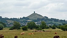
Somerset Levels
[7] The area's topography consists of two basins mainly surrounded by hills, the runoff from which forms rivers that originally meandered across the plain but have now been controlled by embanking and clyses (the local name for a sluice).
Some of the old roads, in contrast to the old hollow ways found in other areas of England, are causeways raised above the level of the surrounding land, with a drainage ditch running along each side.
In the south, Aller, which has a population of 374,[18] includes the hamlet of Beer (sometimes Bere) and the deserted medieval village of Oath on the opposite bank of the River Parrett.
The area known as the Isle of Athelney was once a very low isolated island linked by a causeway to East Lyng, each end of which was protected by a semi-circular stockade and ditch.
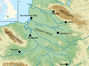
Situated on the edge of the Somerset Levels, along both banks of the River Parrett and 10 miles (16 km) from its mouth, it was at one time a major port and trading centre.
[29] The arrival of the Bristol and Exeter Railway in 1841, which crossed the Axe on a bridge, obstructed river traffic beyond the wharf, making it the limit of navigation for coastal vessels.
[33] The position of the town on the edge of the Somerset Levels has resulted in a history dominated by land reclamation and sea defences since Roman times.
[37] The Azores high pressure area influences the southwest of England's summer weather, but convective cloud sometimes forms inland, reducing the number of hours of sunshine.
[46] In the early 17th century, during the time of King James I, abortive plans were made to drain and enclose much of Sedgemoor, which the local Lords supported but opposed by the Commoners who would have lost grazing rights.
[49] At Westhay Moor in the early 19th century, it was shown how peat bogs could be successfully drained and top-dressed with silt deposited via flooding, creating a very rich soil.
[52] The human-made Huntspill River was constructed during World War II with sluices at both ends to provide a guaranteed daily supply of 4,500,000 imperial gallons (20,000,000 L; 5,400,000 US gal) of "process water".
It has the capacity to hold 1.2 million cubic metres as part of a scheme by the Parrett Internal Drainage Board to restore ten floodplains in Somerset.
In addition, the problems of high fresh water floods are aggravated by the unrestricted entry of the tide along the Parrett,[63] which is the only river in the Levels and Moors that does not have a clyse on it.
Discussions on whether a clyse is needed for the Parrett and whether it should be sited at Bridgwater or nearer the mouth of the river date back to 1939, at the start of World War II, and have not been resolved.
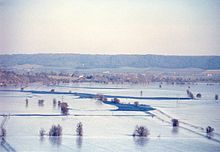
Although there was no loss of life, the resultant flooding covered 12,500 acres (5,100 ha) of land, affecting 1,072 houses and commercial properties, with £150,000 worth of livestock killed and £50,000 of feed and grain destroyed.
[68] Although the Environment Agency have made plans for the regular winter flooding, still in recent years this has resulted in a number of villages — including Muchelney and Westonzoyland — being cut off.
[75] Later during the 7th millennium BC the sea level rose and flooded the valleys, forcing the Mesolithic people to occupy seasonal camps on the higher ground, indicated by scatters of flints.
The remains of similar tracks have been uncovered nearby, connecting settlements on the peat bog including the Honeygore, Abbotts Way, Bells, Bakers, Westhay and Nidons trackways.
[80] Discovered in 1892 by Arthur Bulleid,[81] it was inhabited by about 200 people living in 14 roundhouses,[79] and was built on a morass on an artificial foundation of timber filled with brushwood, bracken, rubble and clay.
[82] Investigation of the Meare Pool indicates that it was formed by the encroachment of raised peat bogs, particularly during the Subatlantic climatic period (1st millennium BC), and core sampling demonstrates that it is filled with at least 2 metres (6.6 ft) of detritus mud.
Products including baskets, eel traps (kypes), lobster pots, and furniture were widely made from willow throughout the area in the recent past.
[122] Among the more unusual products still made are passenger baskets for hot air balloons,[123] the frames inside the Bearskins worn by the regiments of the Grenadier Guards,[124] and an increasing number of willow coffins.
The resulting reduction in water levels put local ecosystems at risk; peat wastage in pasture fields was occurring at rates of 1–3 feet (0.3–0.8 m) over 100 years.
[139] Water voles (Arvicola amphibius) are being encouraged to recolonise areas of the Levels where they have been absent for 10 years, by the capture of mink (Mustela vison).
It aims to ensure that wildlife is enhanced and capable of sustaining itself in the face of climate change[150] while guaranteeing farmers and other landowners can continue to use their land profitably.
Following purchase of land by the National Heritage Memorial Fund, and installation of a water pumping and distribution system along a 550-yard (500 m) section, several hundred metres of the track's length are now being actively conserved.
[160] In 1964, archaeologist John Coles from the University of Cambridge began a research project that resulted in the publication of an important series of papers on many aspects of the Levels.
A range of archaeological projects, such as the exploration of various trackways from the 3rd and 1st millennia BC and the establishment of their economic and geographic significance, was funded by various donors including English Heritage.
Other exhibits show local crafts, including willow coppicing, mud horse fishing on the flats of Bridgwater Bay, peat digging on the Somerset Levels and the production of milk, cheese, and cider.
In reconstructed rooms detailing domestic life in the nearby village of Butleigh, the story of one farm worker, John Hodges, is told from cradle to grave.

Height (m)