Chios
The current castle, with a perimeter of 1,400 m (4,600 ft), was principally constructed during the time of Genoese and Ottoman rule, although remains have been found dating settlements there back to 2000 B.C.
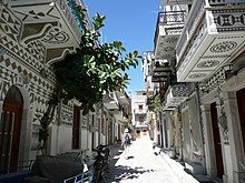
The villages, built between the 14th and 16th centuries, have a carefully designed layout with fortified gates and narrow streets to protect against the frequent raids by marauding pirates.
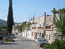
[citation needed] Between Chios Town and the Mastichochoria lie a large number of historic villages including Armolia (Αρμόλια), Myrmighi (Μυρμήγκι), and Kalimassia (Καλλιμασιά).
Directly in the centre of the island, between the villages of Avgonyma to the west and Karyes to the east, is the 11th century monastery of Nea Moni, a UNESCO World Heritage Site.
The monastery was built with funds given by the Byzantine Emperor Constantine IX, after three monks, living in caves nearby, had petitioned him while he was in exile on the island of Lesbos.
The island's climate is warm and moderate, categorised as temperate, Mediterranean (Köppen: Csa), with modest variation due to the stabilising effect of the surrounding sea.
The island normally experiences steady breezes (average 3–5 m/s (6.7–11.2 mph)) throughout the year, with wind direction predominantly northerly ("Etesian" Wind—locally called the "Meltemi") or southwesterly (Sirocco).
[10] A kind of white dirt found near Pyrgi on the southern part of the island[11] was famed as an astringent and cosmetic since antiquity as Chian earth (Latin: Chia terra;[12] Greek: πηλομαιοτικο, pēlomaiotiko).
[11] Extracted around May each year,[11] it was considered less valuable than the similar medicinal earth produced by Lemnos given that the Limnian earth was considered protective against venoms and poisons[11] but nonetheless reputed to be "the greatest of all cosmetics... giv[ing] a whiteness and smoothness to the skin and prevent[ing] wrinkles beyond any of the other substances... for the same purposes.
The primary sites of research for this period have been cave dwellings at Hagio(n) Galas in the north and a settlement and accompanying necropolis in modern-day Emporeio (also known as Emporio) at the far south of the island.
The British School at Athens under the direction of Sinclair Hood excavated the Emporeio site in 1952–1955, and most current information comes from these digs.
The noticeable uniformity in the size of houses at Emporeio leads some scholars to believe that there may have been little social distinction during the Neolithic era on the island.
The naval power of Chios during this period is demonstrated by the fact that the Chians had the largest fleet (100 ships) of all of the Ionians at the Battle of Lade in 494 BC.
[32] During the Third Macedonian War, thirty-five vessels allied to Rome, carrying about 1,000 Galatian troops, as well as a number of horses, were sent by Eumenes II to his brother Attalus.
Eumenes' officers at first thought the intercepting fleet were friendly Romans, but scattered upon realizing they were facing an attack by their Macedonian enemy, some choosing to abandon ship and swim to Erythrae.
In the spring of 14 BC, King Herod of Judaea, known for his extensive architectural projects, funded the construction of a stoa on Chios, which had suffered destruction during the Mithridatic War.
[34] Pliny remarks upon the islanders' use of variegated marble in their buildings, their appreciation for such stone above murals or other forms of artificial decoration,[35] and the cosmetic properties of the local earth.
[37] It has a pinkish coloured background containing yellow-orange, brown and grey spots of variable shape and size, separated by whitish or red veins.
This came to an end when the island was briefly held (1090–97) by Tzachas, a Turkish bey in the region of Smyrna during the first expansion of the Turks to the Aegean coast.
This relative stability was ended by the sacking of Constantinople by the Fourth Crusade (1204) and during the turmoil of the 13th century the island's ownership was constantly affected by the regional power struggles.
After the Fourth Crusade, the Byzantine empire was divided up by the Latin emperors of Constantinople, with Chios nominally becoming a possession of the Republic of Venice.
To prevent Turkish expansion, the island was reconquered and kept as a renewable concession, at the behest of the Byzantine emperor Andronicus II Palaeologus, by the Genovese Benedetto I Zaccaria (1304), then admiral to Philip of France.
The locals, still loyal to the Byzantine Empire, responded to a letter from the emperor and, despite a standing army of a thousand infantrymen, a hundred cavalrymen and two galleys, expelled the Zacharia family from the island (1329) and dissolved the fiefdom.
Again rule was transferred peacefully, as on 12 September the castle was surrendered and a treaty signed with no loss of privileges to the local landowners as long as the new authority was accepted.
[46] When the Greek War of Independence broke out, the island's leaders were reluctant to join the revolutionaries, fearing the loss of their security and prosperity.
It triggered also negative public reaction in Western Europe, as portrayed by Eugène Delacroix, and in the writing of Lord Byron and Victor Hugo.
The 1881 Chios earthquake, estimated as 6.5 on the moment magnitude scale, damaged a large portion of the island's buildings and resulted in great loss of life.
[51] It was affected also by the population exchange after the Greco–Turkish War of 1919–1922, with the incoming Greek refugees settling in Kastro (previously a Turkish neighborhood) and in new settlements hurriedly built south of Chios town.
This ended when the final band of communist fighters was trapped and killed in the orchards of Kampos and their bodies driven through the main town on the back of a truck.
In March 1948, the island was used as an internment camp for female political detainees (communists or relatives of guerillas) and their children, who were housed in military barracks near the town of Chios.