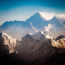
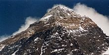
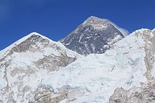
Mount Everest
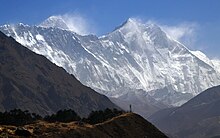
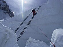
While not posing substantial technical climbing challenges on the standard route, Everest presents dangers such as altitude sickness, weather, and wind, as well as hazards from avalanches and the Khumbu Icefall.
The 1924 expedition resulted in one of the greatest mysteries on Everest to this day: George Mallory and Andrew Irvine made a final summit attempt on 8 June but never returned, sparking debate as to whether they were the first to reach the top.
However, Andrew Waugh, the British Surveyor General of India, claimed that he could not find a commonly used local name, and that his search for one had been hampered by the Nepalese and Tibetan policy of exclusion of foreigners.
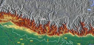
Starting in southern India, the survey teams moved northward using giant theodolites, each weighing 500 kg (1,100 lb) and requiring 12 men to carry, to measure heights as accurately as possible.
[21] In 1852, stationed at the survey headquarters in Dehradun, Radhanath Sikdar, an Indian mathematician and surveyor from Bengal was the first to identify Everest as the world's highest peak, using trigonometric calculations based on Nicolson's measurements.
[32] In 1856, Andrew Waugh announced Everest (then known as Peak XV) as 8,840 m (29,002 ft) high, after several years of calculations based on observations made by the Great Trigonometrical Survey.
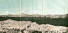
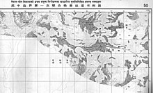
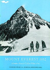
[40] In 1955, a detailed photogrammetric map (at a scale of 1:50,000) of the Khumbu region, including the south side of Mount Everest, was made by Erwin Schneider as part of the 1955 International Himalayan Expedition, which also attempted Lhotse.
This bed, which crops out starting about 70 m (230 ft) below the summit of Mount Everest, consists of sediments trapped, bound, and cemented by the biofilms of micro-organisms, especially cyanobacteria, in shallow marine waters.
They formed as the result of partial melting of Paleoproterozoic to Ordovician high-grade metasedimentary rocks of the Higher Himalayan Sequence about 20 to 24 million years ago during the subduction of the Indian Plate.
[59] Mount Everest consists of sedimentary and metamorphic rocks that have been faulted southward over continental crust composed of Archean granulites of the Indian Plate during the Cenozoic collision of India with Asia.
[70] A minute black jumping spider of the genus Euophrys has been found at elevations as high as 6,700 metres (22,000 ft),[71] possibly making it the highest confirmed non-microscopic permanent resident on Earth.
[140] Double-amputee climber Mark Inglis said in an interview that on 15 May his climbing party, and many others, had passed Sharp, sheltering under a rock overhang 450 metres (1,480 ft) below the summit, without attempting a rescue.
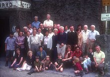
Major McGrath was selected as a 2011 recipient of the Sir Edmund Hillary Foundation of Canada Humanitarian Award, which recognises a Canadian who has personally or administratively contributed a significant service or act in the Himalayan Region of Nepal.
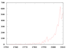
Analysis of the 1996 Mount Everest disaster shows that part of the blame was on the bottleneck caused by a large number of climbers (33 to 36) attempting to summit on the same day; this was considered unusually high at the time.
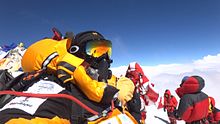
Worldwide publication of images of hundreds of mountaineers queuing to reach the summit and sensational media reports of climbers stepping over dead bodies dismayed people around the world.
[239] According to Jon Krakauer, the era of commercialisation of Everest started in 1985, when the summit was reached by a guided expedition led by David Breashears that included Richard Bass, a wealthy 55-year-old businessman and an amateur mountain climber with four years of climbing experience.
[243][245] Tourism contributed 7.9 per cent of the gross domestic product (GDP) in 2019[246] in a country with high unemployment,[247] but an Everest porter can make nearly double the nation's average wage in a region in which other sources of income are lacking.
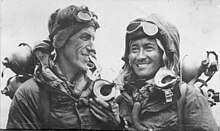
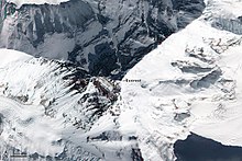
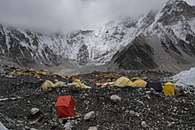
When Hillary and Tenzing climbed Everest in 1953, the British expedition they were part of (comprising over 400 climbers, porters, and Sherpas at that point) started from the Kathmandu Valley, as there were no roads further east at that time.
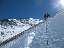
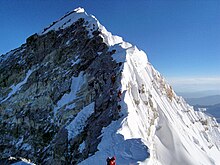
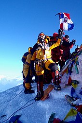
Climbers typically spend less than half an hour at the summit to allow time to descend to Camp IV before darkness sets in, to avoid serious problems with afternoon weather, or because supplemental oxygen tanks run out.
But Mount Everest is now his grave, because only minutes later, he suddenly went blind and had to be abandoned to die from the cold.The team made a huge effort for the next 12 hours to try to get him down the mountain, but to no avail, as they were unsuccessful in getting him through the difficult sections.
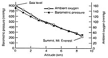
[294] The low oxygen can cause a mental fog-like impairment of cognitive abilities described as "delayed and lethargic thought process, clinically defined as bradypsychia" even after returning to lower altitudes.
In May 2006, Vitor Negrete, the first Brazilian to climb Everest without oxygen and part of David Sharp's party, died during his descent, and theft of gear and food from his high-altitude camp may have contributed.
[303][304] In addition to theft, Michael Kodas describes in his book, High Crimes: The Fate of Everest in an Age of Greed (2008):[305] unethical guides and Sherpas, prostitution and gambling at the Tibet Base Camp, fraud related to the sale of oxygen bottles, and climbers collecting donations under the pretense of removing trash from the mountain.
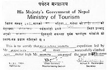
[153] Some notable "firsts" by climbers include: Summiting Everest with disabilities such as amputations and diseases has become popular in the 21st century, with stories like that of Sudarshan Gautam, a man with no arms who made it to the top in 2013.
[352] Reinhold Messner called one of Dickinson's panoramic views of Everest, captured on the now discontinued Kodak Kodachrome film, the "best snap on Earth", according to UK newspaper The Telegraph.
[286][357] After the flight they hiked, biked, and kayaked to the Indian Ocean, reaching the Bay of Bengal by 27 June 2011, thereby becoming the first persons to complete a continuous summit-to-sea descent from Everest.
Ultimately, the Chinese refusal may have been beneficial to Nepal's interests, allowing the government to showcase improved local hospitals and providing the opportunity for a new hybrid aviation/mountaineering style, triggering discussions about helicopter use in the mountaineering world.
[365] Other Everest skiers include Davo Karničar of Slovenia, who completed a top to south base camp descent in 2000, Hans Kammerlander of Italy in 1996 on the north side,[366] and Kit DesLauriers of the United States in 2006.
"[374] For Sherpas living on the slopes of Everest in the Khumbu region of Nepal, Rongbuk Monastery is an important pilgrimage site, accessed in a few days of travel across the Himalayas through Nangpa La.
Climbers above Base Camp—for the 62-year history of climbing on the mountain—have most commonly either buried their excrement in holes they dug by hand in the snow, or slung it into crevasses, or simply defecated wherever convenient, often within metres of their tents.