Climate of Massachusetts
Massachusetts receives about 43 inches or 1,090 millimetres of rain annually, fairly evenly distributed throughout the years, slightly wetter during the winter.
[2] Summers are warm with average high temperatures in July above 80 °F or 26.7 °C and overnight lows above 60 °F or 15.6 °C common throughout the state.
Because its location is farther east in the Atlantic Ocean than states farther south, Massachusetts has suffered a direct hit from a major hurricane three times since 1851, the same number of direct hits suffered by the southern Atlantic state of Georgia.
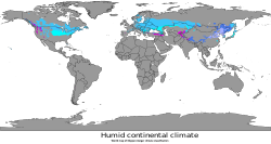
[6] With the exception of southern Connecticut, Cape Cod and the offshore islands, most of New England has a humid continental climate with hot summers and cold winters.
Owing to thick deciduous forests, fall in New England brings bright and colorful foliage attracting tourists.
The humid continental climate is marked by variable weather patterns and a large seasonal temperature variance.
Massachusetts sees a wide variety of temperatures throughout the year, the average being as high as 95 °F (35 °C) in the summertime, and as low as -8 °F (-22 °C) in the wintertime.
Spring in Boston can be warm, with temperatures as high as the 90s when winds are offshore, though it is just as possible for a day in late May to remain in the lower 40s due to cool ocean waters.
[17] Most Nor'easters start from a low-pressure system that forms in the south, most often the Gulf of Mexico, and are drawn across to the Northeast by the jet stream.
The divergence or diffluence in the upper atmosphere caused by the jet stream removes and disperses the rising air at a faster rate than it is replaced at the surface, which, along with the Coriolis Effect, creates and develops a storm.
Their northeast track brings them up the East Coast past the mid-Atlantic and New England coastal states.
The counterclockwise flow around a low pressure system brings the warm moist oceanic air over land.
The deepening low enhances the surrounding pressure gradient, which acts to spiral the very different air masses toward each other at an even faster rate.
[17][18] If the nor'easter takes the East Coast track, that usually indicates the presence of a high pressure area in the vicinity of Bermuda.
[20] The hardest-hit areas included Assumption College, where a priest and two nuns were killed; the main building's 3-foot (0.91 m)-thick brick walls were reduced by three floors, and the landmark tower lost three stories.
[20] A 12-ton bus was picked up, rolled over several times and thrown against the newly constructed Curtis Apartments in Great Brook Valley, resulting in the deaths of two passengers.
Across Boylston St. from the Curtis Apartments, the Brookside Home Farm (a city-operated dairy facility and laundry) sustained total damage, with six men killed and the loss of its herd of 80 cattle.
The hurricane killed over 682 people,[21] damaged or destroyed over 57,000 homes, and caused property losses estimated at $4.7 billion (2005 US dollars).