Hurricane Gloria
After remaining a weak tropical cyclone for several days, Gloria intensified into a hurricane on September 22 north of the Lesser Antilles.
Later that day, Gloria made two subsequent landfalls on Long Island and across the coastline of western Connecticut, before becoming extratropical on September 28 over New England.
In general, Gloria's strongest winds remained east of the center, which largely spared locations from North Carolina to New Jersey, and the passage at low tide reduced storm surge.
In neighboring Canada, the remnants of Gloria caused minor power outages in New Brunswick, although confusion related to the storm's arrival led to the creation of the Canadian Hurricane Centre.
Based on data from satellite imagery, it is estimated that a tropical depression formed on September 16 near Cape Verde,[2] with an associated low-level circulation.
On September 21, the Hurricane Hunters began flying into Gloria to measure the storm's intensity, and the next day, a flight observed winds of 78 mph (126 km/h) at a height of 1,500 ft (460 m).
At 01:20 UTC on September 25, Hurricane Hunters extrapolated a barometric pressure of 919 mbar (27.1 inHg), and reported flight-level winds of 145 mph (233 km/h).
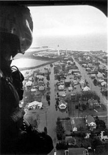
[2][5] At 16:00 UTC on September 27, the hurricane made landfall with a broad and poorly defined center, between John F. Kennedy International Airport and Islip, New York, with sustained winds of 85 mph (137 km/h), on western Long Island.
[11] About an hour after striking Long Island, Gloria made its final landfall in western Connecticut near Westport, and proceeded to move through New England, while weakening.
[6] Early in Gloria's duration, it threatened the northern Lesser Antilles, prompting a hurricane watch and later warning for the area.
[6][12] Officials anticipated higher winds and storm surge[nb 4] than what occurred, due to the hurricane weakening as it approached landfall.
[9] Officials in Delaware and Maryland declared a state of emergency before the storm struck, and thousands of people from coastal communities evacuated to shelters.
Along Long Island in New York, hundreds of thousands of people evacuated their homes, and a state of emergency was declared for several counties.
[10] As Gloria approached the East Coast of the United States, National Hurricane Center director Neil Frank called it the "Storm of the Century", due to its intensity and potential track over the densely populated region of New England.
Cape May County—the most vulnerable part of the state and among the most susceptible in the entire country—would require 36 hours in 2005 to evacuate the 100,000 citizens and 900,000 tourists that were commonly present during busy summer weekends.
Although Gloria's winds downed numerous trees and caused tens of thousands of dollars in damage in the area, overall effects were much less than expected.
[17] At the same time Gloria was making landfall on Long Island, a storm warning was issued for western New Brunswick and Nova Scotia.
[6][12] Across Atlantic Canada, the threat of Hurricane Gloria caused many citizens to rely on American media for storm coverage.
[20] High waves and storm surge resulted in heavy coastal flooding and beach erosion along the Outer Banks,[2] and several new inlets were created.
Due to Gloria's fast motion, there was minimal coastal flooding because the highest storm surge occurred during low tide, generally less than 4.9 ft (1.5 m).
In neighboring Pennsylvania, wind gusts reached 56 mph (90 km/h) in Allentown, which knocked down many trees and left thousands without power.
[10] Though Gloria moved quickly through the region, it dropped moderate rainfall in locations, including 6.04 inches (153 mm) at Baltimore–Washington International Airport.
High winds downed numerous trees throughout the area, leaving hundreds of thousands without power, including 237,000 in New Jersey, 124,000 in Maryland, and 56,000 in Virginia.
The area hit the worst was eastern Long Island, where high wind gusts blew thousands of trees into buildings and across roads.
[24] Prolonged exposure to high winds and waves led to moderate beach erosion, washing away several piers and docks.
The highest reported sustained winds were 83 mph (134 km/h) in Waterbury, Connecticut, and Blue Hill Meteorological Observatory in Massachusetts, although neither location is at sea level.
[24] While the remnants of Gloria were moving through Atlantic Canada, they produced rainfall to the north of the track, reaching as high as 4.53 in (115 mm) in Quebec.
The long duration without electricity forced hundreds of schools to close, extended train times by six hours due to lack of powered crossings, and price gouging on food, ice, and generators.
Citizens quickly protested LILCO's decision, and within years the publicly owned Long Island Power Authority was formed.
[29] After the storm, President Ronald Reagan declared several counties in New Jersey, Pennsylvania, New York, Rhode Island, Connecticut, and Massachusetts as federal disaster areas.

Tropical storm (39–73 mph, 63–118 km/h)
Category 1 (74–95 mph, 119–153 km/h)
Category 2 (96–110 mph, 154–177 km/h)
Category 3 (111–129 mph, 178–208 km/h)
Category 4 (130–156 mph, 209–251 km/h)
Category 5 (≥157 mph, ≥252 km/h)
Unknown