Climate of Peru
The Sechura is warmer and less impacted by the cloud cover that characterizes the more southern parts of the coastal desert, but there is a uniformity in precipitation along the entire coastline with less than 30 mm (1.2 in) annually.
The desert strip along the Pacific is narrow, at its widest about 120 km (75 mi) before the land climbs into the Andes and precipitation increases with elevation.
During the Southern Hemisphere's winter, the trade winds blow thick stratus clouds inland over coastal areas up to an elevation of 1,000 m (3,300 ft) and the dense fog coalesces into drizzle and mist.
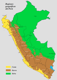
[13] The chain of mountains called the Andes, comprising 28 percent of the national territory, runs the length of Peru, a narrow 80 km (50 miles) wide at the Ecuadorian border in the north and 350 km (220 miles) wide in the south along the border with Bolivia.
[14][15] A general rule for mountainous areas is that temperature decreases by about 6.5 °C (11.7 °F) for each 1,000 m (3,300 ft) increase in elevation provided that the change in altitude takes place at the same latitude and other factors such as precipitation and cloud cover are similar.
The common precipitation regime of the Andes is a rainy summer season from October to April and a dry winter from May to September.
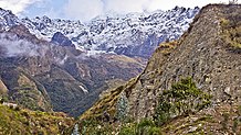
Compensating for the lack of a freeze-free growing season at elevations above 3,000 m (9,800 ft), indigenous farmers up until the 21st century have sought out microclimates and used techniques such as andenes (terraces) and Waru Waru (raised beds) to capture and store heat and permit hardy crops such as potatoes to grow up to 4,050 m (13,290 ft) in elevation.
[22] The Amazon rainforest region comprises about 60 percent of the total area of Peru and is characterized, as is the coast, by its climatic uniformity: hot average temperatures with little variation among the seasons and abundant precipitation.
The true tropical rainforest (Af) climate requires at least 60 mm (2.4 in) precipitation in all months of the year.
In Oxapampa, Cfb under the Köppen classification, temperatures rarely fall below 11 °C (52 °F) or rise above 26 °C (79 °F) and rain is abundant year-round.
Ocean temperatures on the coast of Peru increase by as much as 3 °C (5.4 °F) during the Southern Hemisphere's summer, beginning about Christmas, the name El Niño referring to the birth of Jesus.
In especially impactful years, as occurred in 1982–1983, 1997–1998, and 2015–2017,[25] El Niño causes heavy rainfall in coastal northern Peru in what is a desert that rarely receives any rain at all.
Accelerated glacial melt and the eventual disappearance of glaciers will severely impact the quantity of water available in the coastal and mountain regions.
[29] Being a large country with a long coastline, snow-capped mountains and sizeable forests, Peru's varying ecosystems are extremely vulnerable to climate change.
[32] The Plan categorises existing and future programmes into seven action groups, including: reporting mechanisms on GHG emissions, mitigation, adaptation, research and development of technology of systems, financing and management, and public education.
In 2014, Peru hosted the Twentieth Conference of the Parties of the United Nations Framework Convention on Climate Change (UNFCCC COP20) negotiations.
[33] At the same time, Peru enacted a new climate law which provides for the creation of a national greenhouse gas inventory system called INFOCARBONO.
[34] According to the Low Emission Development Strategies Global Partnership (LEDS GP), INFOCARBONO is a major transformation of the country's greenhouse gas management system.