Weather front
[7] Surface weather analyses have special symbols which show frontal systems, cloud cover, precipitation, or other important information.
If the warm air mass is unstable, thunderstorms may be embedded among the stratiform clouds ahead of the front, and after frontal passage thundershowers may still continue.
On weather maps, the surface location of a warm front is marked with a red line of semicircles pointing in the direction the air mass is travelling.
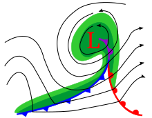
[2] A wide variety of weather can be found along an occluded front, with thunderstorms possible, but usually their passage is also associated with a drying of the air mass.
Precipitations and clouds are associated with the trowal, the projection on the Earth's surface of the tongue of warm air aloft formed during the occlusion process of the depression or storm.
[12] Occluded fronts are indicated on a weather map by a purple line with alternating half-circles and triangles pointing in direction of travel.
With its warm and humid characteristics, this air is susceptive to convective instability and can sustain thunderstorms, especially if lifted by the advancing cold front.
They tend to remain essentially in the same area for extended periods of time, especially with parallel winds directions;[13] They usually move in waves but not persistently.
Stationary fronts are marked on weather maps with alternating red half-circles and blue spikes pointing opposite to each other, indicating no significant movement.
When stationary fronts become smaller in scale and stabilizes in temperature, degenerating to a narrow zone where wind direction changes significantly over a relatively short distance, they become known as shearlines.
A similar phenomenon to a weather front is the dry line, which is the boundary between air masses with significant moisture differences instead of temperature.
When the westerlies increase on the north side of surface highs, areas of lowered pressure will form downwind of north–south oriented mountain chains, leading to the formation of a lee trough.
In the vicinity of the reversal aloft, severe weather is possible, especially when an occlusion or triple point is formed with a cold front.
Dry lines are one of the few surface fronts where the pips indicated do not necessarily reflect the direction of motion.
[18] Organized areas of thunderstorm activity not only reinforce pre-existing frontal zones, but can outrun actively existing cold fronts in a pattern where the upper level jet splits apart into two streams, with the resultant Mesoscale Convective System (MCS) forming at the point of the upper level split in the wind pattern running southeast into the warm sector parallel to low-level thickness lines.
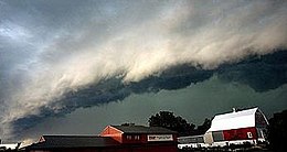
When the convection is strong and linear or curved, the MCS is called a squall line, with the feature placed at the leading edge of the significant wind shift and pressure rise.
If the temperature differences of the two air masses involved are large and the turbulence is extreme because of wind shear and the presence of a strong jet stream, "roll clouds" and tornadoes may occur.
[22] In the warm season, lee troughs, breezes, outflow boundaries and occlusions can lead to convection if enough moisture is available.

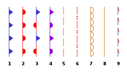
2. warm front
3. stationary front
4. occluded front
5. surface trough
6. squall / shear line
7. dry line
8. tropical wave
9. trough