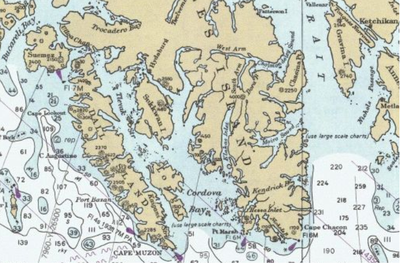
Cordova Bay

Cordova Bay extends north and west from its mouth to Lime Point, where it connects with Hetta Inlet.

In 2006, the US Supreme Court ruled against a petition by Alaska that would have declared all these waters, including Tlevak Strait, parts of a juridical Cordova Bay.

Much of the eastern shore of the bay is part of the South Prince of Wales Wilderness within the National Forest.

South of Hunter Bay, the Prince of Wales shoreline is more gentle, rising to low rolling hills dotted with lakes.

The other three large islands have a mixture of mountainous terrain and hills, with low-lying land at some places along the shore.

Cordova Bay is at the southern end of the Alexander Archipelago in the Alaska Panhandle
Cordova Bay lies between Prince of Wales Island on the east and Dall Island, Long Island, and Sukkwan Islands on the west. US Coast Survey chart detail. Click through to the Commons page to view annotations including village sites.
Cordova Bay photographed from Earth orbit, looking toward the sunrise, a bit north of east. Water appears bright due to sunglint . Dall Island, Long Island, and most of Sukkwan island are visible as dark areas in the middle of the picture, while the land near the top of the picture is Prince of Wales Island. The small island at lower left is Forrester Island. NASA image.