Dall Island
Its land area is 254.0 square miles (657.9 km2), making it the 28th largest island in the United States.
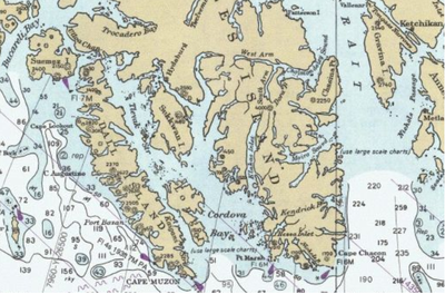
[4][5] Cape Muzon, the southernmost point of the island, is the western terminus, known as Point A, of the A–B Line, which marks the marine boundary between the state of Alaska and the Canadian province of British Columbia, per the position of the Canadian government on the decision of the arbitration tribunal under the Alaska Boundary Treaty of 1903.
Cape Muzon was established as the "point of commencement" of the international boundary between Russia and British North America in the Anglo-Russian Convention of 1825.
[3] The United States Coast and Geodetic Survey charts produced in 1884 and 1894–95 laid the boundary line with Canada from Cape Muzon through Dixon Entrance and Portland Canal.
[3] In its decision on the delimitation of the disputed Alaska Panhandle boundary, the six-judge 1903 Court of Arbitration unanimously agreed that Cape Muzon was the initial point of the boundary[7] and designated Point A as one endpoint of the A–B Line.