County Route 537 (New Jersey)
At this point, the road becomes the border between Pennsauken Township to the north and Camden to the south, meeting the intersection with Terrace Avenue (CR 663).
The route fully enters Pennsauken and turns north and east as a four-lane divided highway, interchanging with US 130 in commercial areas.
CR 537 becomes two lanes and undivided again as it heads into suburban Merchantville as Maple Avenue, passing through wooded areas of homes.
CR 537 becomes Marne Highway at this intersection and turns east as it runs immediately to the south of Conrail Shared Assets Operations' Pemberton Industrial Track line, passing a mix of business parks and fields and enters Mount Laurel.
Upon intersecting with Centerton Road (CR 619), the route turns north as a four-lane divided highway and heads through fields, crossing the railroad tracks and re-enters Moorestown.
At the intersection with Westfield Road (CR 614), CR 537 turns southeast as a two-lane undivided road, re-entering Mount Laurel and turns east and running parallel to the north of the Conrail tracks again as it passes under I-295 and the New Jersey Turnpike, within a short distance of each other.
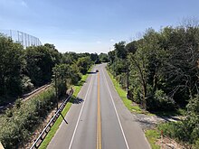
The route heads through more wooded areas of residences as it intersects with Creek Road (CR 636) and enters Hainesport Township.
Farther northeast, CR 537 crosses the intersection with Route 68 and turns more to the east as it passes woods to the north and agricultural areas to the south.
At this point, the route widens into a six-lane divided highway with a Jersey barrier and jughandles, passing a mix of woods and businesses before reaching the interchange with I-195.
Upon crossing the intersection with Thompson Grove Road, the route fully enters Freehold Township and becomes West Main Street, passing more housing developments along with some farms.
From here, the route becomes undivided shortly before passing CentraState Medical Center to the north and enters several business areas.
At this point, the road heads into Freehold Borough on Main Street and passes homes as it intersects with Park Avenue (Route 33 Business).
The route narrows to two lanes as it intersects with Manalapan Avenue (CR 24) and continues into the commercial downtown of Freehold.
At this point, CR 537 passes southeast of the Freehold Center bus terminal and crosses the Freehold Industrial Track railroad line operated by the Delaware and Raritan River Railroad at the intersection with Throckmorton Street (CR 522) before coming to the intersection with South Street (Route 79).
CR 537 continues east-northeast along East Main Street, passing through residential areas and meeting the trailhead of the Henry Hudson Trail.
CR 537 continues past Colts Neck High School, along with more homes, and passes Hominy Hill Golf Course to the south in the Bucks Mill section of the township, before coming to the intersection with Route 34.
On this portion, the road is lined by trees and memorials to U.S. Army Signal Corps soldiers killed during World War II.
[3][4] From Mount Holly to Moorestown, the road was part of a King's Highway extending from South Amboy to Salem, chartered in 1681.
[5] The road that now carries CR 537 through the former Fort Monmouth was originally open to the public but closed after the September 11 attacks.
[7] However as of November 2022[update], signage for CR 537 still appears along the former section of the road from Fort Monmouth's entrance to Long Branch.