New Jersey Route 35
It runs 58.11 mi (93.52 km) from the entrance to Island Beach State Park in Berkeley Township, Ocean County to an intersection with Lincoln Highway/St.
Between Seaside Park and Mantoloking, Route 35 follows the right-of-way of the former Pennsylvania Railroad along the Jersey Shore.
It was realigned onto its current alignment between Brielle and Belmar in 1929 and saw a northward extension along U.s. Route 9 (US 9) from South Amboy to Iselin in 1947.
Route 35 begins at the entrance to Island Beach State Park in Berkeley Township, Ocean County at the southern tip of the Barnegat Peninsula.
South of Seaside Park, Route 35 is Central Avenue as it is the only road while it travels along the shore of the Peninsula.
[1] Route 35 continues north through Bay Head, where the bike lanes end and the road name becomes Main Avenue.
[3] The one-way pair carries the route through the downtown area of Point Pleasant Beach, with the NJ Transit tracks parallel to the east.
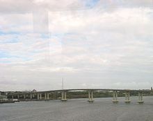
[1] Route 35 crosses into Brielle, Monmouth County, immediately passing over the main channel of the Manasquan River on a drawbridge.
[1] Past the Shark River bridge, Route 35 continues as a four-lane divided highway that features an interchange with Memorial Drive (CR 40A), crossing into Neptune City.
[1] It intersects with (CR 520), running concurrently with that route and immediately crossing the North Jersey Coast Line into Red Bank.
[1] Past the Navesink River, the route runs along a four-lane, divided highway with a jersey barrier, passing through commercial areas.
[1] Along the northbound lanes of Route 35, just before the intersection of Kings Highway, stands the Evil Clown of Middletown, a large sign advertising a liquor store.
It crosses the Cheesequake Creek on a drawbridge into Sayreville and turns to the west, passing over the North Jersey Coast Line.
US 9 and Route 35 split at an interchange (the former Victory Circle) that features access to the southbound direction of the Garden State Parkway by way of Chevalier Avenue, with Route 35 continuing north on a four-lane divided highway that passes through marshland and crosses the Raritan River on the Victory Bridge into Perth Amboy.
In Perth Amboy, the route becomes four-lane, undivided Convery Boulevard upon crossing the intersection of Smith Street (CR 656).
Past the New Jersey Turnpike (I-95), the road heads into residential neighborhoods, crossing the intersection of Main Street (CR 514.
Route 35 merges onto St. Georges Avenue and crosses CSAO's Port Reading Secondary line before it comes to a partial cloverleaf interchange with US 1/9.
Upon entering Rahway, Route 35 crosses under Amtrak's Northeast Corridor rail line just before ending at [[Lincoln Highway/St.
[13] This section of Route 35 follows the right-of-way of the former Pennsylvania Railroad between Seaside Park and Mantoloking, which was removed in 1949.
[17] The highway was turned into a one-way pair between Brick and Seaside Heights in 1961 by utilizing the former right-of-way of the Pennsylvania Railroad.
[27] Because of this, in April 2010, NJDOT initiated construction to relocate the intersection to allow for a straighter roadway and a full cloverleaf configuration around the interchange.
[28] On February 1, 2013, Route 35 through Mantoloking was fully reopened after being closed since October 29, 2012 after Hurricane Sandy hit the area.
[29] Beginning in March 2013 (after a six-month delay due to Hurricane Sandy), a four-year major construction project began on Route 35 between Raritan Boulevard/Birchwood Drive in Cliffwood Beach (Old Bridge) and Amboy Avenue in Aberdeen.
The project includes several highway improvements designed to alleviate the flooding the highway is prone to due to its lowness and being adjacent in several areas to tidal marshes and Whale Creek and Long Neck Creek, widening of four intersections (Birchwood Drive, County Road, Cliffwood Avenue, and Amboy Avenue), and lane alignments, and additions for pedestrian and bicyclist safety.