Garden State Parkway
The highway has a posted speed limit of 65 miles per hour (105 km/h) for most of its length and is primarily for passenger vehicle use; trucks weighing over 10,000 pounds (4,500 kg) are prohibited north of exit 105.
[5] The entire length of the Garden State Parkway carries the unsigned designation of Route 444,[1] and is part of the National Highway System,[6] a network of roads important to the country's economy, defense, and mobility.
Crossing into the county seat of Cape May Court House, the median narrows and US 9 appears within yards of the southbound lanes of the parkway as it passes west of The Shore Club golf course.
Past the service area, the parkway enters Upper Township and reaches the Cape May Toll Plaza northbound immediately before meeting the southern terminus of Route 50, which serves Seaville, at a partial interchange.
After passing east of several homes and a golf course, the parkway has the John B. Townsend Shoemaker Holly Picnic Area in the median before it crosses over the abandoned Pennsylvania-Reading Seashore Lines Ocean City Branch.
[1][3][8] The highway surfaces into Somers Point, Atlantic County, where the southbound roadway has the Great Egg Toll Plaza before US 9 leaves the parkway at a partial junction.
Continuing north, the highway enters Galloway Township and passes over NJ Transit's Atlantic City Line before it comes to a partial interchange with White Horse Pike (US 30), serving Absecon.
With some occasional development appearing along the sides of the road, the median narrows to a Jersey barrier as US 9 merges back onto the parkway, along with the Pine Barrens Byway, and the three routes cross the Mullica River.
Continuing northeast past the community of New Gretna, the parkway passes over US 9 with no access before crossing the Bass River and the median widens and contains a maintenance yard.
Here, the Garden State Parkway interchanges with North Green Street (CR 539), which serves Tuckerton, before entering Eagleswood, where it crosses over Westecunk Creek and passes to the west of Eagles Nest Airport.
After an interchange with West Bay Avenue (CR 554), the parkway passes by residential neighborhoods on both sides of the highway before the median shortly narrows and the southbound roadway has the Barnegat Toll Plaza.
[1][3][8] Father north, the road crosses over Cedar Creek and enters Berkeley Township, passing west of a golf course and Central Regional High School while traversing Double Trouble State Park.
The route then crosses into Beachwood and passes west of several homes before entering South Toms River, where the median narrows and the parkway becomes concurrently with US 9 once again at an interchange with CR 530.
Past the interchange, the parkway reaches the bi-directional Toms River Toll Plaza and passes by lighter suburban development in addition to parkland, with Ocean County College to the east.
Soon afterwards, the parkway passes to the west of the Jersey Shore Premium Outlets and has a partial exit for Asbury Avenue (CR 16), where the road widens to ten lanes.
Continuing northwest past houses and parks, the route has an interchange with Red Hill Road (CR 52) as it enters Holmdel Township, where it serves the PNC Bank Arts Center and the New Jersey Vietnam Veterans' Memorial.
[1][3] After crossing the Cheesequake Creek near a marina and leaving the park, the road enters Sayreville and has the Jon Bon Jovi Service Area in the median, with access to both the express and local lanes of the highway.
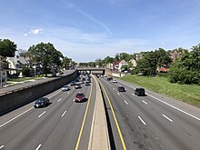
Running northwest through Woodbridge as a ten-lane roadway, the highway has an interchange with US 1 and crosses under Conrail Shared Assets Operations' Port Reading Secondary line as it enters the community of Iselin, passing to the east of several corporate offices.
After passing East Orange General Hospital's Eastern Pavilion, the parkway comes to an interchange with I-280 and Central Avenue (CR 508), which serve Downtown Newark.
At the interchange, the Garden State Parkway loses a lane in each direction and passes under NJ Transit's Morris & Essex Lines near East Orange station.
The parkway continues to run in between frontage roads containing many houses before passing west of several apartment buildings and hospitals and crossing the abandoned Orange Branch of the New York and Greenwood Lake Railway.
Mayor William McConnell ordered a blockade on this section of the highway on January 4, stating that North Arlington Avenue would be unable to handle traffic coming from the parkway.
On November 24, 1970, southbound parkway traffic from there south to the Raritan River was redirected onto a new roadway that lied in the median of the old one, the old were not demolished however, but rather became an exit onto US 9, effectively creating a collector-distributor road.
The interchange, which had the northbound and southbound ramps constructed 1⁄2 mile (0.80 km) away from each other to avoid demolition of the nearby Double Trouble State Park, contains one toll facility in each direction.
[177] The New Jersey Department of Transportation (NJDOT) awarded the project contract to the engineering firm Gannett Fleming for the design, and to Union Paving & Construction Company for building the ramps.
[181] A project that rebuilt the Watchung Avenue overpass at exit 151 in order to add shoulders to the segment underneath and increased safety by being wider and more friendly to pedestrians[182] was completed in 2013.
This proposition was heavily criticized by officials and residents in Somers Point and Ocean City, fearing that traffic congestion would simply be relocated rather than eliminated,[222] as well as reduceing business that relies on the interchange.
These upgrades were suggested either to provide full connections or to improve safety by eliminating obsolete designs such as left hand exits or short deacceleration lanes, as well as to increase future capacity.
[244] On July 27, 2021, the NJTA unanimously voted in favor of renaming the service areas along the Garden State Parkway after New Jerseyans who were inducted into the New Jersey Hall of Fame.
Their ramp terminals became insufficient to accommodate the high-speed mainline traffic and in addition to the decreasing number of users, the picnic areas were becoming more effective as maintenance yards and were converted as such or closed altogether.