Craven Fault System
The broad Aire Gap separates the Yorkshire Dales from the Bowland Fells and the Millstone Grit plateaux of the South Pennines.
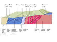
The Middle Craven Fault moved mainly during Carboniferous times and marks the southern limit of the Askrigg Block.
However the North and South Craven faults continued to be active into post-Triassic times.
Near Ingleton, North Yorkshire the North Craven Fault has a downthrow of about 200 metres (660 ft), and a few hundred yards away the South Craven Fault has a downthrow of about 1,200 metres (3,900 ft).
[9] Charles Darwin used the Craven Fault to illustrate how nature can so well conceal dramatic events: "The Craven Fault, for instance, extends for upwards of 30 miles, and along this line the vertical displacement of strata has varied from 600 to 3000 feet.