Cyclone Ada
Forming over the far eastern Coral Sea in early January, the weather disturbance that would become Ada remained weak and disorganised for nearly two weeks as it slowly moved in a clockwise loop.
As Ada moved ashore, most homes were damaged or destroyed in communities near the storm's landfall point, including Cannonvale, Airlie Beach, and Shute Harbour.
Extreme rainfall totals as high as 1,250 mm (49 in) caused massive river flooding in coastal waterways between Bowen and Mackay.
[2] The cyclone continued tracking west-southwest toward Queensland, and at 14:00 UTC on 16 January, it passed over an automated weather station on Marion Reef, about 480 km (300 mi) east of Bowen.
[3][4] With the first direct confirmation of the storm's growing strength, the BoM issued its initial public cyclone warning at 19:00 UTC.
Over the next several hours, radar revealed the system was moving slower and more erratically than expected, occasionally jogging to the east.
[4] As a result of its small size, the storm's onslaught was much more sudden than normal, with little rain and steady barometric pressures in the hours before landfall.
[4] Upon moving ashore, the system slowed and curved toward the south, and after reaching a point about 60 km (40 mi) northwest of Mackay on 18 January, it became nearly stationary.
[1] As Ada reached North Queensland, the BoM issued cyclone warnings on a three-hour cycle, with more frequent bulletins occasionally released as needed.
The bureau's post-storm assessment of the disaster revealed that local broadcasts of advisories were sometimes delayed by several hours or not made at all, and public awareness was generally inadequate.
In a misguided attempt to quell panic, one radio station appended the BoM's warning with an unapproved message that there was no cause for alarm because of the cyclone's small size.
The search for the vessel and her seven occupants was suspended on 26 January, around the same time that wreckage, believed to be from Whakatane, was identified near Long Island.
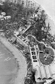
[11] Long Island was subjected to Ada's left-front quadrant—the most intense part of the storm—and the Palm Bay Resort there was devastated, with only a few huts remaining.
[14] As the winds subsided, the weakening cyclone dropped as much as 1.25 m (49 in) of rain, resulting in massive river flooding near the coast.
[1][15] From Bowen north to Townsville, more modest rainfall associated with the upper-level remnants of Ada proved beneficial, helping to alleviate persistent drought conditions.
[21] Private citizens also rushed to the aid of stranded resort guests; in January 2014, a local boat captain was formally honoured by MP George Christensen and Premier Campbell Newman for his role in evacuating 180 people from Daydream Island.
[25] In the islands, about 400 workers rushed to repair the resorts before peak tourism season; by mid-May, about 100 holiday cabins had been rebuilt and 20 boats restored to service.
[29] In 2016, Whitsunday MP Jason Costigan advocated for erecting a memorial to Ada's victims,[7] and community members formed a small committee exploring this possibility in early 2017.
[30] In April 2019, Whitsunday Regional Council voted unanimously to approve $15,000 in funding for a memorial at Airlie Beach to be completed in time for the 50th anniversary of the disaster.
[31] Finally, on 18 January 2020, a stone monument, 1.7 m (5.6 ft) tall and inscribed with the names of the 14 cyclone victims, was unveiled at a ceremony attended by 200 people.

Tropical storm (39–73 mph, 63–118 km/h)
Category 1 (74–95 mph, 119–153 km/h)
Category 2 (96–110 mph, 154–177 km/h)
Category 3 (111–129 mph, 178–208 km/h)
Category 4 (130–156 mph, 209–251 km/h)
Category 5 (≥157 mph, ≥252 km/h)
Unknown