Cyclone Belna
Belna's precursor—an initially broad trough of low pressure west of Seychelles—was formally designated as a zone of disturbed weather on 2 December during a favourable period for tropical cyclogenesis in the Indian Ocean.
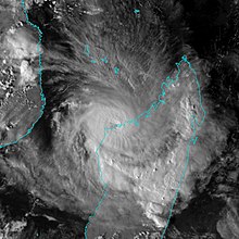
Belna reached tropical cyclone strength on 7 December as it began to turn towards the southwest, peaking with maximum sustained winds of 155 km/h (95 mph) before fluctuating in intensity over the following day as it passed just east of Mayotte.
[2] MFR began highlighting the potential for tropical cyclone development in their daily bulletins on 25 November, noting an increase in shower activity west of Seychelles.
[3] Aided by the passage of a Kelvin wave and a favourable window in the Madden–Julian oscillation, a broad trough of low pressure began to take shape within the storm activity, extending across the equator.
[4][5] Projections from computer models remained in disagreement over the system's future, complicated by the concurrent development of a tropical disturbance in the northwestern Indian Ocean along the same trough.
Due to a strengthening area of high pressure to its east, Belna began to curve from its initial westward drift to a more directed southwestward trajectory.
[15] After a brief period of strengthening,[9] Belna's central dense overcast remained largely unchanged throughout 6 December before signs of resumed intensification emerged by the day's end, followed by the development of another eye 9–19 km (5.6–11.8 mi) across.
Hot towers were detected atop and within the storm's radius of maximum winds, suggesting the onset of a more accelerated rate of intensification.
[20] At 18:00 UTC on 7 December, Belna's winds topped out at 155 km/h (95 mph) before fluctuating at a slightly lower strength over the ensuing day.
[22][23] Belna's strength was highly variable in part due to its small size, making it susceptible to changes in the local atmospheric environment and complicating forecasts.
[24] On 9 December, a new phase of intensification began as Belna approached the Madagascar coast near Soalala, with an eye becoming apparent on visible satellite imagery.
[33] Civil security personnel from mainland France and Reunion, some from the National Gendarmerie, were sent to Mayotte to aid storm preparation efforts there.
[37] Belna ultimately passed 100 km (62 mi) east of Mayotte on the morning of 9 December, with impacts on the island mitigated further by the storm's small size.
Accordingly, cyclone response measures were activated by the National Office for Risk and Disaster Management (BNGRC) and humanitarian organisations across northern Madagascar.

Tropical storm (39–73 mph, 63–118 km/h)
Category 1 (74–95 mph, 119–153 km/h)
Category 2 (96–110 mph, 154–177 km/h)
Category 3 (111–129 mph, 178–208 km/h)
Category 4 (130–156 mph, 209–251 km/h)
Category 5 (≥157 mph, ≥252 km/h)
Unknown