Trough (meteorology)
Near-surface troughs sometimes mark a weather front associated with clouds, showers, and a wind direction shift.
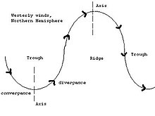
Upper-level troughs in the jet stream (as shown in diagram) reflect cyclonic filaments of vorticity.
Their motion induces upper-level wind divergence, lifting and cooling the air ahead (downstream) of the trough and helping to produce cloudy and rain conditions there.
Sometimes the region between two high pressure centers may also assume the character of a trough when there is a detectable wind shift noted at the surface.
In the absence of a wind shift, the region is designated a col, akin to a geographic saddle between two mountain peaks.
At upper levels of the atmosphere, this occurs when there is a meeting of a mass of cold air and another hot one along a thin ribbon called a frontal baroclinic zone.
[8] The trough will become neutral (North-South) and then negatively tilted as the energy carried by the cold air races east through the atmospheric circulation and distorts its shape.
Some tropical or subtropical regions such as the Philippines or South China are greatly affected by convection cells along a trough.
Tropical waves are a type of trough in easterly currents, a cyclonic northward deflection of the trade winds.