Cyclone Olivia
On 8 April, Olivia intensified into a severe tropical cyclone and subsequently turned more to the south, steered by a passing trough.
On the morning of 10 April, passing over Barrow Island off the Western Australian northwest coast, Olivia produced the strongest non-tornadic winds ever recorded, with peak gusts of 408 kilometres per hour (254 mph).
Despite strong wind shear, the system slowly became better organized as it moved southward,[2] aided by improving upper-level outflow.
[2] Following this, the system had developed sufficiently for the JTWC to upgrade it to a Category 1 equivalent on the Saffir–Simpson Hurricane Scale (SSHS), estimating 1 minute sustained winds of 120 km/h (75 mph).
[3] Around the same time, the BoM upgraded Olivia to a severe tropical cyclone, assessing similar wind speeds but sustained over 10 minutes.
[2][4] After the storm reached this intensity, the mid-level ridge south of the cyclone began to weaken, turning Olivia toward the southwest.
[2] During the afternoon of 9 April, the BoM estimated that Olivia attained its lowest barometric pressure of 925 hPa (mbar), along with 10 minute sustained winds of 195 km/h (121 mph).
[2][4] Around 00:00 UTC on 10 April, the JTWC assessed the cyclone to have attained 1 minute winds of 230 km/h (140 mph), equivalent to a Category 4 on the SSHS.
Early on 10 April, data from a nearby weather radar at the Learmonth Airport near Exmouth, Western Australia, showed that the storm had developed a 65 km (40 mi) wide eye.
[6] As a minimal cyclone in the Timor Sea, Olivia brought some minor rainfall and gusty winds to parts of the Northern Territory.
[2] Waves toppled an oil drilling structure about 40 km (25 mi) northeast of Barrow Island, the first of its kind to fail since the 1980s.
On Barrow Island, the winds knocked over 30 pumpjacks,[9] and several buildings and instruments were damaged, while high waves incurred beach erosion.
[11] Ahead of the storm, hundreds of residents in older structures and mobile homes, as well as an aboriginal village near Onslow, were ordered to evacuate to safer locations.
[14] Farther inland, Olivia still produced wind gusts of 158 km/h (98 mph) in Pannawonica, which damaged many roofs, trees, and power lines.
Several other small towns in the region sustained damage to roofs, power lines, and trees,[21] and a 24 year old roadhouse was destroyed along the Fortescue River.
Cape Willoughby recorded gusts of 106 km/h (66 mph) on 12 April, strong enough to knock down tree branches on nearby Kangaroo Island.
This gust surpassed the previous non-tornadic wind speed of 372 km/h (231 mph) on Mount Washington in the United States in April 1934.
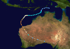
Tropical storm (39–73 mph, 63–118 km/h)
Category 1 (74–95 mph, 119–153 km/h)
Category 2 (96–110 mph, 154–177 km/h)
Category 3 (111–129 mph, 178–208 km/h)
Category 4 (130–156 mph, 209–251 km/h)
Category 5 (≥157 mph, ≥252 km/h)
Unknown