Cyclone Lam
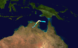
The system crossed over the Cape York Peninsula and moved into the Gulf of Carpentaria, whereupon it gradually organized due to warm waters and favorable outflow.
On February 16, the Bureau of Meteorology (BoM) classified it as a Category 1 on the Australian tropical cyclone intensity scale and gave it the name Lam.
[3] The system moved slowly westward into the Cape York Peninsula without much development,[4] entering the Gulf of Carpentaria on February 15,[5] as it was steered by a ridge to the south.
As a result, the BoM began classifying it as Tropical Low 13U at 06:00 UTC on February 16 while the system was about 235 km (145 mi) northwest of Weipa, Queensland.
[6] On the same day, the Joint Typhoon Warning Center (JTWC) issued a tropical cyclone formation alert, noting the decreasing wind shear and warm water temperatures of over 30 °C (86 °F).
[8] At 18:00 UTC on February 16, the BoM upgraded the low to a Category 1 on the Australian tropical cyclone intensity scale, naming it Lam.
At that time, the BoM anticipated the cyclone would intensify to peak 10 minute sustained winds of 185 km/h (115 mph) within 72 hours,[9] which proved very accurate.
At 06:00 UTC that day, the BoM upgraded Lam to a Category 3 Severe Tropical Cyclone with 10 minute winds of 120 km/h (75 mph), equivalent to a minimal hurricane.
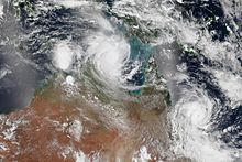
[5][12] When Lam was passing near Cape Wessel, the lower and middle level circulations were slightly displaced, although the center was embedded within the deepest convection.
[14] At 12:00 UTC on February 19, the BoM upgraded Lam to a Category 4 cyclone, estimating peak 10 minute winds of 185 km/h (115 mph); this was based on the well-defined eye and rainbands on satellite imagery.
[16] About six hours after Lam moved ashore, Cyclone Marcia made landfall along Queensland, making it the first time on record that two storms of at least Category 4 intensity struck Australia on the same day.
[19] When the BoM first classified Lam as Tropical Low 13U, the agency also issued a cyclone watch for the Cape York Peninsula and Arnhem Land.
[19] Upon striking Northern Territory, Cyclone Lam produced estimated wind gusts of 230 km/h (145 mph), which knocked down many trees and power lines.
[30] Farther inland, Lam dropped heavy rainfall that caused flooding, peaking at 258.5 mm (10.18 in) at Diljin Hill along the Waterhouse River.
[35] The Northern Territory government established a tent city on the offshore Elcho Island,[36] which was dismantled on March 20 due to the threat of approaching Cyclone Nathan.
Tropical storm (39–73 mph, 63–118 km/h)
Category 1 (74–95 mph, 119–153 km/h)
Category 2 (96–110 mph, 154–177 km/h)
Category 3 (111–129 mph, 178–208 km/h)
Category 4 (130–156 mph, 209–251 km/h)
Category 5 (≥157 mph, ≥252 km/h)
Unknown