Cyclone Tino
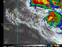
Whilst losing latitude, the system continued to strengthen and peaked as a category 3 tropical cyclone on January 17, with signs of an eye forming.
Shortly after peak intensity, Tino was impacted by high wind shear and decreasing sea surface temperatures, triggering a weakening trend.
Roads and crops were damaged in Tonga following Tino's passage on January 18 near peak strength, with the worst effects afflicting the island groups of Vavaʻu and Ha'apai.
Waves as high as 8 m (26 ft) struck Tuvalu's low-lying atolls and surrounding waters, causing catastrophic flooding and uprooting numerous crops.
During January 11, the Fiji Meteorological Service (FMS) reported that Tropical Disturbance 04F had developed, about 410 km (255 mi) to the southwest of Honiara in the Solomon Islands.
[1][2] The disturbance was also located to the north of a subtropical ridge of high pressure, within a favourable environment for further development, with a low to moderate amount of vertical wind shear and warm sea surface temperatures of 29–31 °C (84–88 °F).
[1][2] Over the next couple of days, the system slowly consolidated and gradually developed further, as it was steered eastwards by the ridge through Temotu Province of the Solomon Islands.
[3][4] The system was subsequently classified as a tropical depression during January 15, while it was located about 570 km (355 mi) to the northeast of Port Vila in Vanuatu.
[5][6] As a result of this and decreasing vertical wind shear, the United States Joint Typhoon Warning Center issued a tropical cyclone formation alert on the system.
[12][13] During January 18, the FMS reported that Tino had become a Category 3 severe tropical cyclone and had peaked with 10-minute sustained wind speeds of 120 km/h (75 mph).
[18] The JTWC then issued their final advisory on the system during January 19, before it was last noted during the next day, as MetService declared that Tino had become an extratropical low.
[20] Despite passing over 500 km (310 mi) to the south of the island nation, Tino and its associated convergence zone impacted the whole of Tuvalu between January 16 - 19.
[23] As the storm made its passage, waves as high as 8 m (26 ft) combined with a king tide swept through the atoll's low-lying land, causing catastrophic flooding.
[24] The government of Tuvalu declared a state of emergency for the country on 24 January, estimating that approximately half of the nation was "severely affected" by Tino.
[27] They warned that strong to gale-force winds of between 45–65 km/h (30–40 mph) were expected in the island group, with heavy rain, squally thunderstorms and sea flooding of coastal areas during high tides.
[37][38] Over the next few days, the FMS gradually replaced the tropical cyclone alert, with gale and storm warnings for various islands in the archipelago, including Lakeba, Cicia and Tuvuca.
[47] In preparation of the storm, villagers in the Udu Point region of Vanua Levu were urged to move inland due to rough forecast seas.
[49] The Fiji National University campus in Labasa and other businesses in the town closed on January 17,[52][53] as did all schools in the Northern and Eastern divisions.
[57] As Tino passed close to Vanua Levu, the second cyclone to pass near the nation within three weeks following Sarai, Fijian government officials called for urgent action on the 'climate crisis' in the South Pacific region, with Fijian Ambassador to the United Nations Satyendra Prasad tweeting "Fiji is counting mode to its 2nd cyclone in [2019-20] today.
[59] A father and daughter went missing after attempting to cross a flooded creek due to heavy rainfall generated by the system in Serua Province.
[76] Following the storm, the NDMO dispatched a team alongside other government officials to deliver relief supplies to the southern Lau Islands.
The Vavaʻu and Ha'apai island groups of Tonga bore the brunt of the storm's impacts, experiencing gusts estimated at 180 km/h (110 mph).
[87] In the storm's aftermath, Papua New Guinea Prime Minister James Marape promised US$860,000 in relief aid for nearby countries affected by Tino, including Tonga.
[89] The Vanuatu Meteorology and Geohazards Department also issued heavy rain warnings for the provinces of Torba, Sanma, Penama and Tafea.
Residents on Wallis reported downed trees, flooded roads, and damaged homes as winds affected the islands on January 17–18.
[96][97] The convergence zone and Tino's outer rainbands brought squally conditions to the Samoan Islands between January 18–19 as the cyclone passed to the south.
[105] Waves also crashed on to cliff tops between 20–30 metres (70–100 ft) high, while coastal areas on the eastern side of the island suffered damage to sea tracks and temporary huts.
[107][108] In particular, it was noted that the system would produce a storm surge, high seas, squally thunderstorms, heavy rain and strong winds of between 35–55 km/h (20–35 mph) on the islands of Rarotonga, Aitutaki, Mangaia and Palmerston.
[107][109] As a result, authorities urged residents to take precautionary measures, stay away from the beach and to be cautious of high tides, while they set up the national auditorium as an emergency evacuation centre.

Tropical storm (39–73 mph, 63–118 km/h)
Category 1 (74–95 mph, 119–153 km/h)
Category 2 (96–110 mph, 154–177 km/h)
Category 3 (111–129 mph, 178–208 km/h)
Category 4 (130–156 mph, 209–251 km/h)
Category 5 (≥157 mph, ≥252 km/h)
Unknown