Diacria quadrangle
[3] The Phoenix lander's landing site (68.22° N, 234.25° E) lies about 186 km (116 mi) north of the northeastern quarter of the Diacria quadrangle.
The landscape viewed by the Phoenix lander is probably representative of a large portion of the terrain in the northern Diacria quadrangle.
The feature was named by Greek astronomer E. M. Antoniadi in 1930 after Diacria, the highlands around Marathon in north-west Attica, Greece.
The large crater Milankovič (118.4 km in diameter) is located in the north central portion of the quadrangle at 54.7° N, 213.3° E. Elevation data from the Mars Orbital Laser Altimeter (MOLA) instrument on the Mars Global Surveyor spacecraft shows that the regional terrain slopes gently downward to the northwest, with the highest elevation about 3.5 km (2.2 mi) above datum (Mars "sea level") on the western flank of the Alba Mons volcano in the southeastern portion of the quadrangle.
[5] The regional relief is thus about 8 km, but at a local scale, slopes are very shallow; the portion of Amazonis Planitia in the south central part of the quadrangle contains some of the flattest terrain on the entire planet.
For about as far as the camera can see, the land is flat, but shaped into polygons between 2–3 meters in diameter and is bounded by troughs that are 20 to 50 cm (8 to 20 in) deep.
Pictures of the surface under the lander appear to show that the landing rockets may have exposed a layer of ice.
The flank has a very low slope (l° or less) and is characterized by lava flows and an outwardly radiating array of ridges and channels.
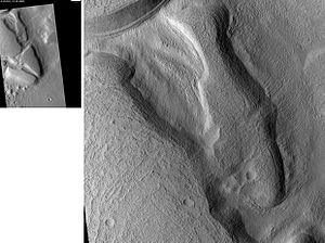
[22] Near the southeast corner of the quadrangle (37° N, 225° E) lies a southward sloping, semicircular block of ancient, heavily cratered, highland crust that is dissected by numerous, arcuate troughs (Acheron Fossae).
The Acheron Fossae region is partially covered by volcanic deposits from Alba Mons in the east, geologically young basaltic lava flows or sediments in the west and southeast, and the jumbled, furrowed terrain of Lycus Sulci in the south.
[23] Lycus Sulci (24.6° N, 219° E) is the name applied to the northwestern portion of a larger terrain feature that partially encircles Olympus Mons and extends up to 750 km from the giant shield volcano's base.
This feature, called the Olympus Mons aureole, consists of several large lobes and has a distinctive corrugated or grooved surface texture.
East of Olympus Mons, the aureole is partially covered by lava flows, but where it is exposed it goes by different names (Gigas Sulci, for example).
The origin of the aureole remains debated, but it was likely formed by huge landslides or gravity-driven thrust sheets that sloughed off the edges of the Olympus Mons shield.
The presence of numerous partly filled "ghost" craters in the area indicates that the hills represent the high-standing remnants of ancient highland crust that was inundated by lava flows and (possibly) alluvial sediments from Tharsis in the southeast and the Elysium volcanic province to the west.
[25] North and east of the Erebus Montes are low-lying plains that characterize a large part of the Diacria Quadrangle and of the Martian northern hemisphere in general.
Medium resolution Mariner 9 and Viking spacecraft images from the 1970s show that large portions of Arcadia Planitia have an overall mottled (blotchy light and dark) appearance.
Arcadia Planitia and Vastitas Borealis likely consist of a hodgepodge of old lava flows, ice-related features, and reworked sediments of diverse origin.
In this region, are many expanded secondary craters that probably form from impacts that destabilize a subsurface layer of excess ice, which subsequently sublimates.
After the ice disappears into the atmosphere, dry soil material will collapse and cause the crater diameter to become larger.
[29] A study reported in the journal Science in September 2009,[30] shows that some newly formed craters have excavated clean, water ice from just below the surface in five locations on Mars.
The ice was confirmed with the Compact Imaging Spectrometer (CRISM) on board the Mars Reconnaissance Orbiter (MRO).
[31][32][33] This discovery is significant because it shows the presence of subsurface ice at latitudes further south than expected and proves that future colonists on Mars will be able to obtain water from a wide variety of locations.
Research, published in January 2012 in Icarus, found that dark streaks were initiated by airblasts from meteorites traveling at supersonic speeds.
[42] Data from the Thermal Emission Spectrometer (TES) on the Mars Global Surveyor spacecraft has allowed planetary scientists to estimate the amount of dust cover for broad swaths of the planet.
A few large patches of relatively low dust cover occur in Amazonis Planitia and in the northwest corner of the quadrangle.
[44] Many areas on Mars, including the Diacria quadrangle, experience the passage of giant dust devils.
[46] The triangular depressions visible in Milankovič crater contain water ice in the straight wall that faces the pole, according to a new study.
[53] Martian gullies are small, incised networks of narrow channels and their associated downslope sediment deposits, found on the planet of Mars.
[57][58][59][60] Indeed, a study published in June 2017, calculated that the volume of water needed to carve all the channels on Mars was even larger than the proposed ocean that the planet may have had.