Diamantina River
[3] The major feature of the river's sluggish course is Diamantina National Park about halfway between Winton and Birdsville.
Apart from the national park, almost all land in the basin is used for grazing cattle and sheep, though numbers fluctuate greatly and considerable skill is required on the part of graziers.
The highest recorded flow rate of the river was at Birdsville in 1974 with 4,700 cubic metres per second (170,000 cu ft/s) was measured.
[8] The Diamantina runs along the northern and eastern rim of a roughly circular zone measuring some 130 km across that has been identified by Geoscience Australia as a crustal anomaly.
Although they do not have high phosphate contents, they have adequate levels of most other nutrients: consequently when rainfall is abundant the grasses within the basin are extremely nutritious, especially in the lower reaches of the river around Birdsville, which is a primary region for cattle fattening in years when rainfall further north is adequate to flood the region.
The 3,400-square-kilometre (1,300 sq mi) floodplain of the lower reaches of the Diamantina has been identified as an Important Bird Area by BirdLife International because it has been estimated to support at least 450,000 waterbirds when in flood, as well as globally significant numbers of the nankeen night-heron, royal spoonbill, little curlew, Australian bustard, grey grasswren, inland dotterel, cinnamon quail-thrush and pied honeyeater.
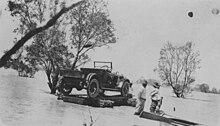
During the floods of 1940 the mailman, Harry Ding, completed his round using a motorboat and Cooper Creek was measured at around 43 kilometres (27 mi) wide.