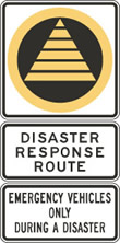
Disaster Response Route
DRR came to the Province after witnessing the traffic mayhem after disasters like the 1989 San Francisco and 1994 Los Angeles earthquakes; and the September 11 terrorist attacks.
[2] In the original plan, only Vancouver roads were considered but eventually expanded to marine routes, railways and air transports.
[3] While DRR consists mostly of roads, emergency plans also includes marine routes suitable for quick access for responders.
[5] Since 2004, the Ministry of Transportation added the third tab and increased public awareness to promote the correct use of these roads during a disaster.
Roads that are pre-marked as DRR are open to the general public unless a state of emergency was declared by the municipal or provincial government.