Drought in Australia
Drought in Australia is defined by the Australian Bureau of Meteorology as rainfall over period greater than three-months being in the lowest decile of what has been recorded for that region in the past.
Specifically, drought in Australia is defined in relation to a rainfall deficiency of pastoral leases and is determined by decile analysis applied to a certain area.
During the drought, the wheat crop was "all but lost", and the Darling River was dry at Bourke, New South Wales, for over a year, from April 1902 to May 1903.
[12] The rains were only a brief respite, and 1940 was one of the driest years of the century over most of southern Australia, emptying the Nepean Dam in New South Wales and imposing water restrictions in Brisbane.
[13] Artist Russell Drysdale undertook 3-week 5000km tour, at the height of WW2, of wind-eroded drought-stricken areas on commission from The Sydney Morning Herald.
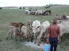
"[15] Its effect on agriculture was profound, with millions of cattle dying, many because the stock routes south were too dry to sustain their journey.
[16] Artist Sidney Nolan, on commission from the Brisbane Courier-Mail, produced a series of photographs of their dried carcasses,[17] but the results were judged by editors to be too confronting and the article carried his drawings from the pictures instead.
[19] The drought in 1982–83 is regarded as the worst of the twentieth century for short-term rainfall deficiencies of up to one year and their over-all impact.
[24] In June 1994, more than ten towns had lost irrigation systems; and some areas had gone five years without decent rainfall.
Cotton farms near Moree and Narrabri had been allocated no water for irrigation, which resulted in a major loss of production.
From 1996 to 2010, south-eastern Australia experienced prolonged dry conditions with rainfall persistently well below average, particularly during the cooler months from April to October.
[26] Dry conditions began to emerge in south-eastern Australia during late 1996 and intensified during the strong 1997 El Niño event.
[31] South-east Australia experienced its second driest year on record in 2006, particularly affecting the major agricultural region of the Murray–Darling basin.
The rainfall dramatically increased surface water storage and soil moisture, effectively ending the drought in the south-east.
[42] Wetter conditions in 2016 eased the effects of drought in eastern Australia, but pockets of south-east Queensland and north-east New South Wales remained drier than average.
[52] In October 2019, Australia's Bureau of Meteorology stated that drier and warmer and drier than average conditions were expected to persist at least until the end of the year with no relief in sight for most of the drought affected areas, influenced at least in part by a positive Indian Ocean Dipole and a prolonged period of negative SAM (Southern Annular Mode) during October and November.
[54] As of December 2019[update] the drought was continuing – including the driest November across Australia on record[55] – but the Bureau of Meteorology reported that the positive Indian Ocean Dipole had weakened to around 50% of its peak seen in mid October, possibly indicating a future improvement in conditions later in the Australian summer.
[56] From 7-10 February 2020, many areas on the east coast of New South Wales received heavy and continuous rain, the heaviest falls for thirty years.
In March 2021, above average rainfall led to serious and destructive flooding in the Hawkesbury-Nepean catchment and on the Mid North Coast of New South Wales.
[59] In November 2013 the Australian Government released a $500 million drought stimulus package, including an additional $2 million in loans under the Regional Investment Corporation under a reconfigured payment schedule, an extension to the existing Drought Communities Program which provides money to regional Councils, and supplementary payments under the Roads to Recovery program to assist with job creation in drought-affected areas.
[62] Dry conditions in September 2019 contributed to several small to mid-range fires in north eastern New South Wales.
By November of that year, continuing heat and lack of rain had desiccated the forests and agricultural land along the Great Dividing range in New South Wales and Queensland.
Numerous intense bushfires occurred,[63] some of which burnt Gondwanan rainforest remnants that had not experienced fires for millennia.