Astronauts David Scott and James Irwin visited the south rim of it in 1971, on the Apollo 15 mission, during EVA 2.
The south rim of Dune was designated Geology Station 4 of the mission.
[1] The following samples were collected from Dune Crater (Station 4), as listed in Table 5-II of the Apollo 15 Preliminary Science Report.
[3] Sample type, lithology, and description are from Table 5-IV of the same volume.
Samples 15470 to 15476 were collected near where the rover was parked to the south of the rim of Dune.
A telephoto view from the slope of
Mons Hadley Delta
at station 6A facing north shows Dune in the foreground. The
LM
Falcon
is near the center, and the
North Complex
is beyond the LM.
Dune crater, facing north, with
Mons Hadley
at right. This is part of Pan D-6 in the planimetric map below.
Planimetric map of Station 4 from the
Apollo 15 Preliminary Science Report
.
X
indicates sample locations, 5-digit
numbers
are
LRL
sample numbers,
rectangle
is
lunar rover
(dot indicates TV camera),
black spots
are large rocks,
dashed lines
are
crater
rims or other topographic features, and
triangles
are
panorama
stations.
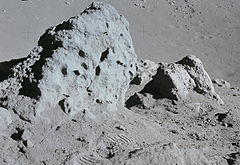
Much of the activity at station 4 was devoted to the boulders shown in this photograph. These boulders are basalts and represent material excavated during the formation of Dune Crater. The crew reported that vesicles were abundant in the boulders at this location and that some vesicles were as large as 9 cm in diameter. The abundance and size of the vesicles in these boulders suggest that this basaltic material cooled on or very near the lunar surface. (NASA Image and caption)